Approximate Location Map
Large Map »
Latitude: 53.0118 / 53°0'42"N
Longitude: -4.1027 / 4°6'9"W
OS Eastings: 259025
OS Northings: 348123
OS Grid: SH590481
Mapcode National: GBR 5Q.GCVV
Mapcode Global: WH556.YKHF
Plus Code: 9C5Q2V6W+PW
Entry Name: Pont Beddgelert
Listing Date: 29 April 1952
Last Amended: 25 November 1998
Grade: II
Source: Cadw
Source ID: 3676
Building Class: Transport
ID on this website: 300003676
Location: Spanning the Afon Colwyn in the centre of the village.
County: Gwynedd
Town: Caernarfon
Community: Beddgelert
Community: Beddgelert
Traditional County: Caernarfonshire
Tagged with: Bridge Road bridge
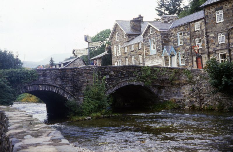
There was presumably a bridge in this location already before the Dissolution, giving access to the Augustinian priory of Beddgelert from the northern side of the river. By 1623 the bridge was recorded as being in need of repair and was repaired and widened again in 1778. Much of the bridge appears to have been swept away in a flood of 1799 and was again repaired and doubled in width between 1802 and 1811. In the latter year a toll was established on the bridge for the turnpike road. Further repairs were carried out c1890 and in 1906.
Triple-arched rubble road bridge, doubled in width on the downstream side; set on a cobbled plinth-raft, projecting beyond the bridge proper on both up- and downstream sides. Rough-dressed voussoirs to segmental arches, with narrow stones forming projecting arch-rings. The central arch is the largest, with a slightly smaller N arch and a small flood-arch to the S. The carriageway is gently humped to the centre and on each side is a refuge contained within a triangular cutwater. Long slatestone capping stones to rubble parapets, splayed at the approaches. On the inner downstream splay at the N end are inset milestones of incised slate, probably late C19 or early C20. That on the L is inscribed: 'To Penygwryd 7; to Llanberis 13, to Capel Curig ..[indistinct]'. That to the R is inscribed: 'To Portmadoc Miles 7 1/2.
On the N side of the bridge the splayed parapets continue beyond the approaches as low rubble walls; these run parallel with the river on both sides with rough coping stones and extend for approximately 100m, with an average road-side height of 0.60m and a reveted river-side height of approximately 3m. In the angle with the bridge on the downstream side is a squinch. The downstream S side also adjoins a (rebuilt) rubble wall, which extends for a similar distance at an average height of 1m.
Listed for its special interest as a road bridge of sub-medieval origin in a prominent location in the village centre.
Group value with other listed items in Beddgelert village centre.
External links are from the relevant listing authority and, where applicable, Wikidata. Wikidata IDs may be related buildings as well as this specific building. If you want to add or update a link, you will need to do so by editing the Wikidata entry.


Other nearby listed buildings
