Approximate Location Map
Large Map »
Latitude: 51.8564 / 51°51'22"N
Longitude: -3.1423 / 3°8'32"W
OS Eastings: 321424
OS Northings: 218148
OS Grid: SO214181
Mapcode National: GBR F0.T95P
Mapcode Global: VH6CH.HL4R
Plus Code: 9C3RVV45+G3
Entry Name: Crickhowell Bridge (partly in Crickhowell community)
Listing Date: 21 October 1998
Last Amended: 21 October 1998
Grade: I
Source: Cadw
Source ID: 20716
Building Class: Transport
ID on this website: 300020716
Location: Located between Crickhowell and Llangattock communities 0.4km NE of the Church of St. Cattwg. The bridge crosses the River Usk, and extends southwards, with its southernmost arch spanning the Nant O
County: Powys
Community: Llangattock (Llangatwg)
Community: Llangattock
Locality: Legar
Traditional County: Brecknockshire
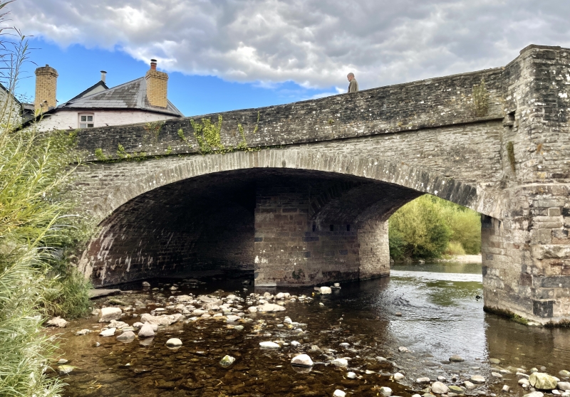
First recorded in a survey of 1538, but rebuilt in 1706 with more arches. Later alterations included widening in 1810 to the NW side, having been criticised by Theophilus Jones for its narrowness, and reconstruction to the NE end when New Road was built in 1828-30. This reduced the upstream side by one arch.
Single carriageway bridge of partly coursed rubble masonry, gently ramped towards the centre. Thirteen-arch to SE downstream side and 12-arch to NW upstream side. Low segmental arches of varying widths. V-shaped cutwaters and refuges to parapets built as one. Flat coping stones to parapets. The detail of the 2 sides differs as a result of the widening in 1810. The SE downstream side is of 1706; it is constructed of narrow, roughly coursed stone with no string course. The arches are recessed with narrow voussoirs. Some of the parapets and arch heads have been rebuilt in larger blocks. The NW upstream side has a stringcourse and the arches are not recessed. The NW half of the abutments, cutwaters and some of the arched heads have been almost entirely rebuilt in large blocks of red and blue stone. The bridge divides at the NE end, the R fork, Bridge Street, being the original route and New Street being the addition of 1828-30. The new (L) fork has 1 wide arch rather than 2.
Listed grade I as a particularly special example of this building type, one of Wales' finest early bridges.
Scheduled Ancient Monument No BR005.
External links are from the relevant listing authority and, where applicable, Wikidata. Wikidata IDs may be related buildings as well as this specific building. If you want to add or update a link, you will need to do so by editing the Wikidata entry.


Other nearby listed buildings
