Approximate Location Map
Large Map »
Latitude: 53.0852 / 53°5'6"N
Longitude: -3.7954 / 3°47'43"W
OS Eastings: 279845
OS Northings: 355727
OS Grid: SH798557
Mapcode National: GBR 64.9NHR
Mapcode Global: WH663.NQV5
Plus Code: 9C5R36P3+3R
Entry Name: Waterloo Bridge
Listing Date: 30 May 1996
Last Amended: 30 May 1996
Grade: I
Source: Cadw
Source ID: 17827
Building Class: Transport
ID on this website: 300017827
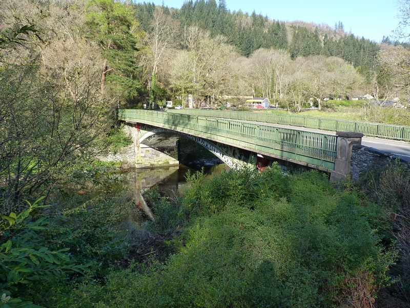
Location: Carrying the A5 at the SE approach to Betws-y-Coed, spanning the Afon Conwy.
County: Conwy
Community: Betws-y-Coed
Community: Betws-y-Coed
Traditional County: Caernarfonshire
Tagged with: Arch bridge Road bridge
History: Cast iron road bridge built 1815-16 by Thomas Telford, engineer, as an important part of the new Shrewsbury to Holyhead road (A5), itself a heroic achievement in contemporary engineering and road building terms. The Waterloo Bridge, originally known as Llynnon Bridge, is thought to be the seventh major iron bridge in the world and with a span of over 30m is an impressive example of early iron technology. Its patriotic decorative expression and jingoistic dating inscription reveal a spirit of pioneering confidence and optimism during this important period of Britain's industrial and political growth. The bridge was founded by W. Hazeldine and the construction foreman was W. Stuttle.
Description: Wide single span iron road bridge, with masonry springing. The segmental arch bears the cast lettering: `This arch was constructed in the same year the battle of Waterloo was fought.' The spandrels contain bold foliate decoration, depicting the national emblems, the rose, thistle, shamrock and leek, partly polychromed. At the Betws end (W) appears, in raised lettering:` Thomas Telford Engineer;' at the E end appear the names of the founder and foreman, and the date 1815 to the centre. The arch soffit is reinforced with modern concrete coffering; the simple cast iron balustrades have been cantilevered outwards slightly in recent years.
Listed Grade 1 as a highly important and imaginatively-designed iron road bridge by Thomas Telford, engineer, a significant example of early iron technology.
References: RCAHMW Caernarvonshire, Vol.1., East, 1956, 20(89).
Atlas to the life of Thomas Telford, 1838).
E Hubbard, Clwyd, Buildings of Wales Series, (1986) p.105.
External links are from the relevant listing authority and, where applicable, Wikidata. Wikidata IDs may be related buildings as well as this specific building. If you want to add or update a link, you will need to do so by editing the Wikidata entry.


Other nearby listed buildings
