History in Structure

Buttington Bridge

A Grade II Listed Building in Gungrog, Powys

More Photos »
Approximate Location Map
Large Map »

Coordinates

Latitude: 52.6727 / 52°40'21"N

Longitude: -3.1156 / 3°6'56"W

OS Eastings: 324659

OS Northings: 308911

OS Grid: SJ246089

Mapcode National: GBR B1.4PM9

Mapcode Global: WH79Q.32MX

Plus Code: 9C4RMVFM+3P

Entry Name: Buttington Bridge

Listing Date: 11 March 1981

Last Amended: 24 January 1995

Grade: II

Source: Cadw

Source ID: 15647

Building Class: Transport

ID on this website: 300015647

County: Powys

Community: Trewern (Tre-wern)

Community: Trewern

Locality: Buttington

Built-Up Area: Gungrog

Traditional County: Montgomeryshire

Tagged with: Road bridge

Find accommodation in
Welshpool

History

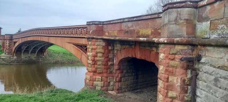
The main road bridge across the River Severn, partly in the Community Area of Welshpool.

Exterior

Single-span bridge built in 1872, by W.N.Swettenham, County Surveyor for Montgomeryshire. Five elliptical iron arches reinforced with later steel framing, springing from rusticated stone abutments, and having a cast iron parapet consisting of zig-zag line with bold trefoil decoration, cast in two halves in sections approximately 1.6m long. The abutments have very shallow elliptical land arches of yellow stone with red sandstone quoin decoration and keystones, and rise to small refuges at road level. The bridge is approached by causeways of rusticated stone on both sides.

Reasons for Listing

An interesting late use of cast iron in prefabricated sections to provide a worthy major river bridge.

External Links

External links are from the relevant listing authority and, where applicable, Wikidata. Wikidata IDs may be related buildings as well as this specific building. If you want to add or update a link, you will need to do so by editing the Wikidata entry.

Recommended Books

Other nearby listed buildings

  • II The Malthouse
    On the west bank of the River Severn, immediately south of Buttington Bridge, approached via a track which crosses the railway close to the river bank at the western end of the bridge. The malthouse
  • I Church of All Saints
    Located at the junction of the main Shrewsbury to Welshpool road and the B4388, the Leighton Road, near the crossing of the River Severn.
  • II Buttington Vicarage
    The building lies some 200 yards S of Buttington Church.
  • II The Green Dragon Inn
    Lying 300m E of Buttington Bridge.
  • II Buttington Limekilns
    Built into the E bank of the Montgomeryshire Canal immediately N of Bridge 115.
  • II Bridge 115 over the Montgomeryshire Canal
    Carries the lane over the canal at Buttington Wharf, immediately W of the roundabout on the A483 at Buttington Cross.
  • II Mount Pleasant
    At the division of Rhallt Lane and Gugnrog Fawr Lane, 250m approx. W of the roundabout on the A483 at Buttington Cross.
  • II Gungrog Farmhouse
    NE of the town, in a sheltered site approached via the lane leading to Gungrog Hall, which leaves Salop Road close to its junction with the A483 Wels

BritishListedBuildings.co.uk is an independent online resource and is not associated with any government department. All government data published here is used under licence. Please do not contact BritishListedBuildings.co.uk for any queries related to any individual listed building, planning permission related to listed buildings or the listing process itself.

British Listed Buildings is a Good Stuff website.