History in Structure

Bier House at Church of St Cynog

A Grade II Listed Building in Glasbury, Powys

More Photos »
Approximate Location Map
Large Map »

Coordinates

Latitude: 52.0455 / 52°2'43"N

Longitude: -3.2731 / 3°16'23"W

OS Eastings: 312787

OS Northings: 239333

OS Grid: SO127393

Mapcode National: GBR YV.F6RL

Mapcode Global: VH6BG.7V09

Plus Code: 9C4R2PWG+6Q

Entry Name: Bier House at Church of St Cynog

Listing Date: 30 August 2012

Last Amended: 30 August 2012

Grade: II

Source: Cadw

Source ID: 87657

ID on this website: 300087657

Location: At the northern corner of the churchyard within the centre of the small village of Boughrood.

County: Powys

Community: Glasbury (Y Clas-ar-wy)

Community: Glasbury

Locality: Boughrood

Traditional County: Radnorshire

Find accommodation in
Llanstephan

History

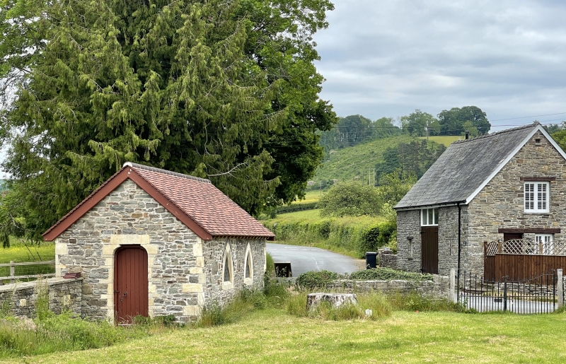
Probably built with the main church in 1854 and designed by the same architect (CH Howell). Its location within the corner of the churchyard was probably deliberate to achieve the arrangement of the new church within the centre of the circular churchyard and the Bier House set apart on the edge.

Exterior

Bier House in Decorated Gothic style to match the church. Constructed of grey snecked and squared sandstone rubble and limestone dressings. Later corrugated roof cover with crested ridge tiles. Single storey. Doors to east and west elevations, east door offset to left, west door centred and both with shouldered arched lintels. 2 cusped lancet windows to south elevation, extremely squat and compressed as to be almost triangular (formerly with small pane leaded glazing). North elevation blind.

Interior

Plain interior with 2 simple strut framed roof trusses.

Reasons for Listing

Included for its special architectural interest as a rare surviving example of an unusual building type and for displaying good use of materials and design. Group value with church.

External Links

External links are from the relevant listing authority and, where applicable, Wikidata. Wikidata IDs may be related buildings as well as this specific building. If you want to add or update a link, you will need to do so by editing the Wikidata entry.

Recommended Books

Other nearby listed buildings

  • II Church of St Cynog
    The church is located near the centre of a large circular graveyard, at the centre of the small village of Boughrood.
  • II The Forge
    Located on the perimeter road around Boughrood Churchyard, N of the church.
  • II* Boughrood Cottage
    Located 100m to the NW of Boughrood church across a small tributary of the River Wye, within its own grounds, and with its farmyard, buildings and mill to the N.
  • II* Boughrood Court
    Located 100m to the NW of Boughrood church across a small tributary of the River Wye, within its own grounds, and with its farmyard, buildings and mill to the N.
  • II Village Farmhouse
    Located on the SE side of the perimeter road around the circular graveyard of Boughrood Church, approximately 200m from the church building.
  • II Barn and cowhouse range formerly with Village Farm
    Located on the SE side of the perimeter road around the circular graveyard of Boughrood Church, approximately 200m from the church building, and forming the NW and NE side of the farm yard behind Vil
  • II Neuadd
    Located on the right bank of a small tributary of the River Wye, approximately 250m from Boughrood Church.
  • II Boughrood Castle
    Located E of Boughrood church, and S of the medieval castle site at Castle Farm, and approached by a driveway from the Boughrood to Glasbury Road.

BritishListedBuildings.co.uk is an independent online resource and is not associated with any government department. All government data published here is used under licence. Please do not contact BritishListedBuildings.co.uk for any queries related to any individual listed building, planning permission related to listed buildings or the listing process itself.

British Listed Buildings is a Good Stuff website.