Approximate Location Map
Large Map »
Latitude: 52.1906 / 52°11'26"N
Longitude: -3.5095 / 3°30'34"W
OS Eastings: 296906
OS Northings: 255784
OS Grid: SN969557
Mapcode National: GBR YJ.4240
Mapcode Global: VH5D9.460H
Plus Code: 9C4R5FRR+75
Entry Name: Church of St Afan
Listing Date: 12 January 2001
Last Amended: 12 January 2001
Grade: II
Source: Cadw
Source ID: 24520
Building Class: Religious, Ritual and Funerary
ID on this website: 300024520
Location: Set in a large churchyard adjacent to the main road and opposite the Red Lion Inn. In a very prominent position with fine views all around.
County: Powys
Town: Builth Wells
Community: Llanafanfawr (Llanafan Fawr)
Community: Llanafanfawr
Traditional County: Brecknockshire
Tagged with: Church building
The church has early medieval origins, evidence including a C7-9 pillar stone and contemporary stone fragments with inscribed Celtic designs which are set into the porch. St Afan, a bishop, probably of the C6, is said to be buried SE of the church. The tower is dated 1765 but appears to be on medieval foundations. It was funded by the parishioners and carried out by Thomas Thomas, undertaker, and the churchwardens, M Morgan Gwilliam and John Jones. In 1887 the church was rebuilt on a smaller scale by S W Williams, with the exception of the tower and the N wall of the nave. The platform for the former chancel is visible in the churchyard, whilst the original nave was extended slightly to incorporate both nave and chancel.
West tower, nave and chancel in single chamber, and S porch, in simple lancet style. Constructed of rubble stone under slate roofs with timber eaves cornice. The windows are cusped lancets, mainly paired, under pronounced hoodmoulds with square stops. The unbuttressed 3-stage tower is on a splayed plinth with string course. Battlemented parapets, also with string course, raised to the NW angle for a staircase. On the S side at ground level is a single cusped lancet. At mid-level is a narrow rectangular light, underneath which is a stone tablet reading 'This steeple was erected ... expense ... Thomas Thomas undertake ... Churchwardens 1765.' Above the light is a stone sun dial. The top stage has an inserted 2-light belfry opening with plain lancets under a relieving arch. The W side of the tower has a similar belfry opening and narrow light at mid-level. Belfry opening only to N side.
The gabled porch is offset to the L and has a pointed chamfered arch with hoodmould, raised copings and kneelers. Inside the porch, the entrance has a pointed arch with double chamfer and planked double doors. On the E side, a small stoup is attached to the wall. Three stones with incised Celtic designs are built into the fabric. To the L of the porch is a pair of lancets and to the R, 3 lancets, then a pair, followed by a single lancet. The E end has a 3-light window with stepped lancets and a hoodmould as elsewhere. Three grave slabs are fixed to the wall, that to the L is to Thomas Thomas (d. 1813) and his wife. Two pairs of lancets are inserted into the N wall, and there is a butt joint to the far L, showing where the original nave was extended.
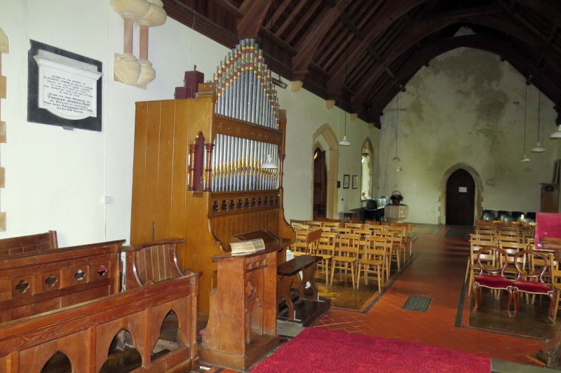
Nine-bay arch-braced roof with collars, dentilled to the upper sides. The braces are supported on small stone corbels set beneath a panelled, dentilled wall plate. Double arch-brace dividing nave and chancel with rounded stone corbels on red marble shafts, with smaller corbels set beneath. Attached shafts between E window lights with rounded capitals. Pointed chamfered arched doorway to tower. Wood panelled pulpit on octagonal stone base with open trefoil decoration to panels. C19 octagonal font in SW corner with incised quatrefoil decoration. The chancel has 2 rows of choir stalls to each side, with open trefoil and quatrefoil decoration. In the N wall of the chancel towards the L, is a low pointed arched opening, now blocked, formerly an alcove for a stove. To the far R of the N wall is a trefoil-headed aumbry. Between the latter and the altar is a pillar stone of C7-9 with incised Celtic cross. A C13 font is to the R of the altar, small and circular on a circular stem.
There are a number of wall monuments in the chancel, including on the N wall, an oval stone tablet with decorated surround to Elizabeth, wife of Rees Jones (d. 1791). To its L is a white marble tablet inscribed with a heart, in a grey stone frame with pilasters supporting a triangular pediment bearing a dove. It commemorates John Price (d. 1804) of Dol y Felin, his wife and 2 sons. An early C20 brass plaque to its L is to further members of the same family. Leaning against the wall is a stone grave slab with round head, bearing 3 urns beneath the arch, to Gwenn, wife of Rees Price, of Cwmdulas (d. 1783), and daughter. A simple C20 tablet to the far R commemorates the C16 biblical translator, Thomas Huet. On the S wall are 2 further tablets to the Price family of Dol y Felin, and a C19 marble tablet to the Joseph family.
Listed primarily for its fine tower of C18 date, with the mainly Victorian church retaining its character also. The prominent siting, its association with St Afan and the C7-9 work are of additional historic interest.
External links are from the relevant listing authority and, where applicable, Wikidata. Wikidata IDs may be related buildings as well as this specific building. If you want to add or update a link, you will need to do so by editing the Wikidata entry.


Other nearby listed buildings
