History in Structure

Fynnon y Pant

A Grade II Listed Building in St Brides Major, Vale of Glamorgan

More Photos »
Approximate Location Map
Large Map »

Coordinates

Latitude: 51.4692 / 51°28'9"N

Longitude: -3.6125 / 3°36'44"W

OS Eastings: 288093

OS Northings: 175702

OS Grid: SS880757

Mapcode National: GBR HC.LL1M

Mapcode Global: VH5HQ.BBLK

Plus Code: 9C3RF99Q+M2

Entry Name: Fynnon y Pant

Listing Date: 3 March 1999

Last Amended: 3 March 1999

Grade: II

Source: Cadw

Source ID: 21794

Building Class: Water Supply and Drainage

ID on this website: 300021794

Location: Located on Ogmore Down, along a track leading down towards Ogmore.

County: Vale of Glamorgan

Community: St. Bride's Major (Saint-y-Brid)

Community: St. Bride's Major

Locality: Heol y Mynydd

Traditional County: Glamorgan

Tagged with: Architectural structure

Find accommodation in
Saint Brides Major

History

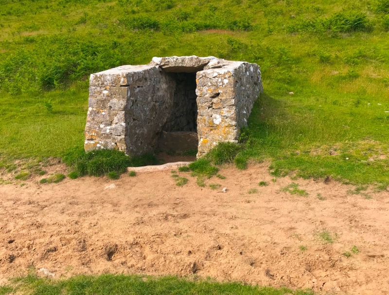
Covered stone well, said to be C16. Possibly rebuilt later.

Exterior

Low, rubble stone cover slab roof, roughly rectangular plan with rounded corners. The entrance is to the S, within flanking walls. After 2 thresholds and a large step, the passage curves round to the E with 2 further steps leading down to the water level beneath and another stone slab lintel below external ground level.

Reasons for Listing

Listed as an unusual survival of an early stone well, which is well preserved.

External Links

External links are from the relevant listing authority and, where applicable, Wikidata. Wikidata IDs may be related buildings as well as this specific building. If you want to add or update a link, you will need to do so by editing the Wikidata entry.

Recommended Books

Other nearby listed buildings

  • II Evergreen Cottage
    Fronting the S side of the common at Heol y Mynydd, on a narrow lane leading from St. Brides Major.
  • II Stables at Ogmore Farm
    Located off the NW side of the B4524 in Ogmore hamlet. Located to the SW of Ogmore Farm on the opposite side of the farmyard.
  • II Ogmore Farm
    Located off the NW side of the B4524 road in the hamlet of Ogmore. Located on a bend of the short lane which leads from the road to Ogmore Castle and the River Ewenny.
  • II Old Star Cottage
    Located off the NW side of the B4524 road in Ogmore. At the end of a short lane which leads from the road down to the River Ewenny. Opposite Ogmore Castle.
  • I Ogmore Castle
    Located on the SE side of the River Ewenny, just before it joins the Ogmore River, in the hamlet of Ogmore to the NW of the B4524. A series of stepping stones cross the river at this point.
  • II* Church of St Bridget
    Set within a polygonal churchyard on the hillside, towards the NW end of St. Brides Major.
  • II Churchyard Cross, Church of St Bridget
    Located on the N side of the Church of St. Bridget, to the E of the porch. The platform is built into the hillside which slopes down to the N.
  • II Sunshine House
    Located in a prominent position in Southerndown village, at the junction of the B4524 and a lane which runs to Heol y Mynydd.

BritishListedBuildings.co.uk is an independent online resource and is not associated with any government department. All government data published here is used under licence. Please do not contact BritishListedBuildings.co.uk for any queries related to any individual listed building, planning permission related to listed buildings or the listing process itself.

British Listed Buildings is a Good Stuff website.