Approximate Location Map
Large Map »
Latitude: 52.923 / 52°55'22"N
Longitude: -4.2714 / 4°16'17"W
OS Eastings: 247396
OS Northings: 338596
OS Grid: SH473385
Mapcode National: GBR 5J.MT0N
Mapcode Global: WH44D.CS7H
Plus Code: 9C4QWPFH+6C
Entry Name: Churchyard Wall and Lychgate to the Church of St John the Baptist
Listing Date: 31 March 1999
Last Amended: 31 March 1999
Grade: II
Source: Cadw
Source ID: 21578
Building Class: Religious, Ritual and Funerary
ID on this website: 300021578
Location: The churchyard wall separates the encircling road from the oval graveyard on the S; the lychgate provides access to the churchyard from the road on the W side, opposite the tower.
County: Gwynedd
Town: Criccieth
Community: Llanystumdwy
Community: Llanystumdwy
Traditional County: Caernarfonshire
Tagged with: Lychgate
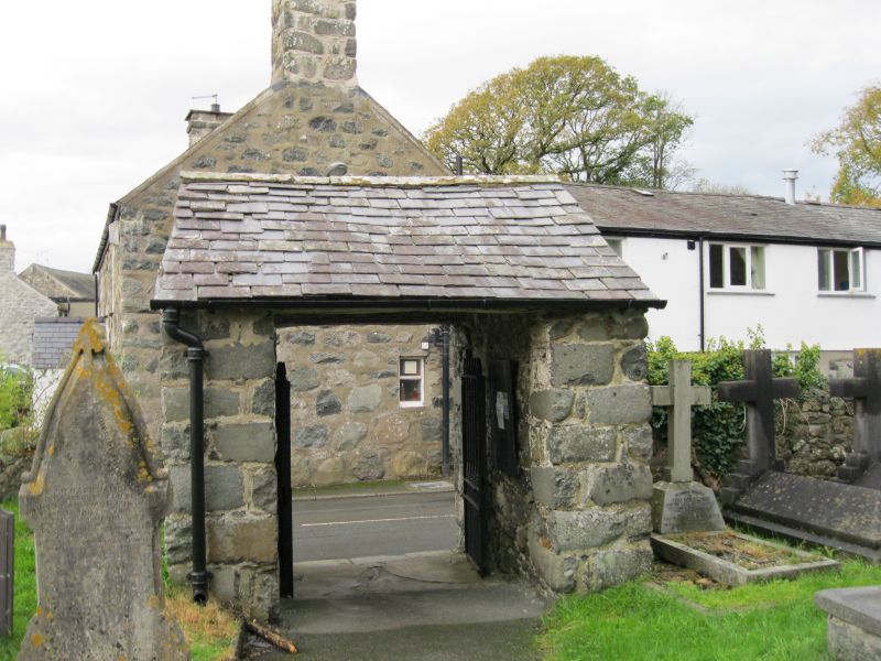
The churchyard wall is probably of medieval origin in part, the lychgate an addition of the C18.
The churchyard wall is c1.5m high, built with rounded river boulders on large boulder foundations and coped with crenellated stones. A broad radius curve carries the wall around the corner to the lychgate, beyond which it steps down to the NW corner, whence it returns along the driveway of Ty'n llan.
The lychgate faces W towards Gwindy. A simple rubble-built gabled structure with side walls, returning back and front and supporting iron gates. The roof is slated. The paired gates have square rails and dog rails, all with fluted conical finials, and are harr hung at the bottom. Single purlin roof, using re-used timber, and the soffit is plastered between limewashed rafters.
Included as features of simple vernacular character, and as an important element at the historic core of the village conservation area.
External links are from the relevant listing authority and, where applicable, Wikidata. Wikidata IDs may be related buildings as well as this specific building. If you want to add or update a link, you will need to do so by editing the Wikidata entry.


Other nearby listed buildings
