History in Structure

Pont y Gaseg

A Grade II Listed Building in Bethesda, Gwynedd

More Photos »
Approximate Location Map
Large Map »

Coordinates

Latitude: 53.1751 / 53°10'30"N

Longitude: -4.057 / 4°3'25"W

OS Eastings: 262616

OS Northings: 366197

OS Grid: SH626661

Mapcode National: GBR 5S.3YTP

Mapcode Global: WH54G.NG97

Plus Code: 9C5Q5WGV+26

Entry Name: Pont y Gaseg

Listing Date: 25 April 1997

Last Amended: 25 April 1997

Grade: II

Source: Cadw

Source ID: 18380

Building Class: Transport

ID on this website: 300018380

Location: Situated some 500m S of centre of Bethesda, S of R.C. church.

County: Gwynedd

Town: Bangor

Community: Bethesda

Community: Bethesda

Built-Up Area: Bethesda

Traditional County: Caernarfonshire

Tagged with: Bridge Road bridge

Find accommodation in
Bethesda

History

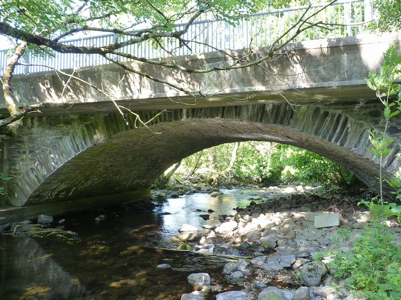
Early C19 road bridge carrying Thomas Telford's Holyhead road over the River Caseg. Marked on 1889 O.S. as 'Pont y Gaseg or Pont Aberogwen'.

Exterior

Rubble stone single arched road bridge. Broad elliptical arch with squared stone voussoirs, string course above, and two raking buttresses each side. String course broken forward over outer buttresses. Rubble stone W parapet with slate edge-on coping. Bridge has been widened on E side with flat concrete span, but not altering bridge structure except for loss of E parapet.

Reasons for Listing

Handsome single span road bridge, possibly designed by Thomas Telford as part of the Holyhead road.

External Links

External links are from the relevant listing authority and, where applicable, Wikidata. Wikidata IDs may be related buildings as well as this specific building. If you want to add or update a link, you will need to do so by editing the Wikidata entry.

Recommended Books

Other nearby listed buildings

  • II Cae'rberllan
    Situated some 600m S of centre of Bethesda, at right angles to A5 backing on to lower slopes of hillside.
  • II Cae'rberllan
    Situated some 600m S of centre of Bethesda, at right angles to A5 backing on to lower slopes of hillside.
  • II Cae'rberllan
    Situated some 600m S of centre of Bethesda, at right angles to A5 backing on to lower slopes of hillside.
  • II Cae'rberllan
    Situated some 600m S of centre of Bethesda, at right angles to A5 backing on to lower slopes of hillside.
  • II Cae'rberllan
    Situated some 600m S of centre of Bethesda, at right angles to A5 backing on to lower slopes of hillside.
  • II Cae'rberllan
    Situated some 600m S of centre of Bethesda, at right angles to A5 backing on to lower slopes of hillside.
  • II Cae'rberllan
    Situated some 600m S of centre of Bethesda, at right angles to A5 backing on to lower slopes of hillside.
  • II Cae'rberllan
    Situated some 600m S of centre of Bethesda, at right angles to A5 backing on to lower slopes of hillside.

BritishListedBuildings.co.uk is an independent online resource and is not associated with any government department. All government data published here is used under licence. Please do not contact BritishListedBuildings.co.uk for any queries related to any individual listed building, planning permission related to listed buildings or the listing process itself.

British Listed Buildings is a Good Stuff website.