Approximate Location Map
Large Map »
Latitude: 52.4849 / 52°29'5"N
Longitude: -3.436 / 3°26'9"W
OS Eastings: 302580
OS Northings: 288415
OS Grid: SO025884
Mapcode National: GBR 9M.JGPR
Mapcode Global: VH687.DSCX
Plus Code: 9C4RFHM7+XH
Entry Name: Llandinam Institute
Listing Date: 26 November 1996
Last Amended: 26 November 1996
Grade: II
Source: Cadw
Source ID: 17778
Building Class: Recreational
ID on this website: 300017778
Location: Located in a prominent position in the centre of the village.
County: Powys
Community: Llandinam
Community: Llandinam
Built-Up Area: Llandinam
Traditional County: Montgomeryshire
Tagged with: Architectural structure
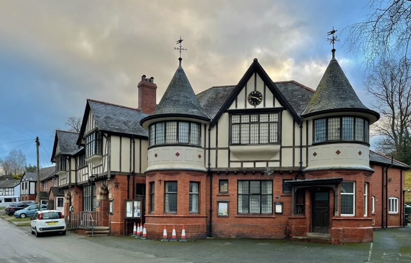
The Institute, which contains a library and meeting rooms, was given to the community by Edward Davies of Plâs Dinam c.1896 as a village community centre. The construction took place c.1905-10; the architect is not known.
Hard red Buttington type brick on ground floor, timber framed with plastered infill panels to the jettied upper floor, and slated roofs. Two storeys. The plan comprises a rectangular structure with symmetrical elevation to Waulk Mill Lane, the main entrance at the left, leading to a 5-bay meeting hall at the rear, a triangular library, now meeting room, to the right of the passage, also symmetrical on elevation with corner towers, and a rectangular 2-storey caretaker's house attached to the rear SW corner of the meeting hall. The round-arched entrance, heavily quoined with stone, has a recessed pair of boarded doors. Canted bay window set centrally to the Waulk Mill Lane elevation. A secondary entrance, with a timber canopied porch is in the SW tower. Hardwood windows with transom and leaded glazing, the openings with radial brick voussoirs. Moulded brick detail provides the transition from the octagonal tower bases to the circular upper level, which have moulded plaster panels. Central 5-light transomsed oriel window with bellied sill. The round towers have similar windows and conical roofs with ironwork finials. The main hall at the rear has double transomed hardwood windows with leaded lights.
Entrance hall is lined with glazed brick. High panelled dado in hall, which has a wide span trusses open to collar level, and hatch to servery at far end.
Included as a well-preserved and ambitiously designed building illustrating the beneficence of the Davies family towards their home village.
External links are from the relevant listing authority and, where applicable, Wikidata. Wikidata IDs may be related buildings as well as this specific building. If you want to add or update a link, you will need to do so by editing the Wikidata entry.


Other nearby listed buildings
