Approximate Location Map
Large Map »
Latitude: 52.4875 / 52°29'15"N
Longitude: -3.2988 / 3°17'55"W
OS Eastings: 311906
OS Northings: 288528
OS Grid: SO119885
Mapcode National: GBR 9T.J6JF
Mapcode Global: VH689.RQYX
Plus Code: 9C4RFPQ2+2F
Entry Name: Cwm-Weeg
Listing Date: 12 September 1996
Last Amended: 12 September 1996
Grade: II
Source: Cadw
Source ID: 17305
Building Class: Domestic
ID on this website: 300017305
Location: Located on a platform site on the lower slope of a side valley off the narrow valley of the Afon Miwl, and now accessed by a farm track from the Dolfor to Kerry road, immediately E of the junction wi
County: Powys
Town: Newtown
Community: Kerry (Ceri)
Community: Kerry
Locality: Penarron
Traditional County: Montgomeryshire
Tagged with: Architectural structure
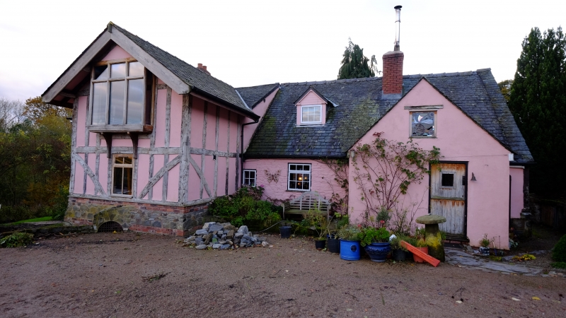
The building of later medieval origins, was probably shortened at the N end by the removal of a lean-to, and extended at the S into the former barn. A later large porch is added to the E front.
Rendered, with an exposed cruck frame on the N gable, and slate roof. One storey and attic, the S end, formerly the barn, now 2 storey accommodation. Boarded door in porch and paned timber windows, and one gabled dormer on the E side. Brick stacks. The building has been extended on the W by a glazed conservatory.
The early section now consists of 2 bays, defined by 3 cruck trusses, originally with an open hearth, replaced by an inserted stone stack, probably in the late C16. Cruck frames survive to near ground level, and have collars, and morticed apex trenched for the ridge (Alcock Type C). They carry one tier of trenched purlins and stub ties to the wall posts. A cellar exists under the first bay of the two-storey section.
Included as a house originating as an open-hall medieval longhouse, thus of significant historical interest, and retaining a proportion of its original construction intact.
External links are from the relevant listing authority and, where applicable, Wikidata. Wikidata IDs may be related buildings as well as this specific building. If you want to add or update a link, you will need to do so by editing the Wikidata entry.


Other nearby listed buildings
