Approximate Location Map
Large Map »
Latitude: 51.3914 / 51°23'28"N
Longitude: -3.3211 / 3°19'16"W
OS Eastings: 308174
OS Northings: 166641
OS Grid: ST081666
Mapcode National: GBR HR.RM9X
Mapcode Global: VH6FQ.D937
Plus Code: 9C3R9MRH+GH
Entry Name: The Old School House
Listing Date: 3 November 1975
Last Amended: 30 September 2004
Grade: II
Source: Cadw
Source ID: 13398
Building Class: Religious, Ritual and Funerary
ID on this website: 300013398
Location: Adjoining the Churchyard of the Church of St. Curig on the west side.
County: Vale of Glamorgan
Town: Barry
Community: Rhoose (Y Rhws)
Community: Rhoose
Locality: Porthkerry
Traditional County: Glamorgan
Tagged with: House
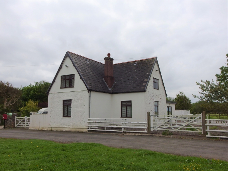
Probably early C17; shown on the 1622 Manorial Map and described as the Church House; it is known as Church House in RCAHMW where it is shown as being of two builds, though evidence for this was not available at resurvey. It is also said that the poor appear to have been housed in the ground floor chambers, while the upper room, accessible by means of an external stone stair against the north-west elevation, was used for parochial functions, Court Leets etc. It was used as a school 1840-70. In the later C20 it has been extended, re-roofed and re-featured.
Colourwashed plastered cladding, presumably over local rubblestone, Welsh slate gabled roof, though formerly known to have been thatched, red ridge tiles. Two storeys, single depth plan with an added rear wing.
Main or north-west elevation of three bays with, on the first floor three iron framed windows with iron glazing bars, four panes wide with the centre portions opening outwards. One similar window on ground floor, a modern window and a modern gabled porch. Large rubble stack to left hand gable end, stack in front of ridge to right hand gable end. Left gable end blind, including the later wing. Right gable has external stone stair leading to upper hall door, now replaced by another iron framed window, seven panes wide with two opening sections. This gabled section has a lower ridge and another iron window with central opening casement in the gable end. Rear elevation entirely rewindowed with factory made timber casements.
The interior was not available for inspection at resurvey. RCAHMW records that inside the upper floor originally comprised a single large unheated chamber; while there were two chambers to the ground floor with straight-cut stops with fillet and chamfered beams. The hall has a large fireplace and a bread oven.
Included as a C17 building which has had interesting historic uses and, despite alteration, has retained much of its character.
External links are from the relevant listing authority and, where applicable, Wikidata. Wikidata IDs may be related buildings as well as this specific building. If you want to add or update a link, you will need to do so by editing the Wikidata entry.


Other nearby listed buildings
