Approximate Location Map
Large Map »
Latitude: 51.4001 / 51°24'0"N
Longitude: -3.5321 / 3°31'55"W
OS Eastings: 293513
OS Northings: 167896
OS Grid: SS935678
Mapcode National: GBR HG.R27W
Mapcode Global: VH5J4.Q2KJ
Plus Code: 9C3RCF29+24
Entry Name: The Cavalry Barracks
Listing Date: 10 September 1982
Last Amended: 19 January 2005
Grade: II
Source: Cadw
Source ID: 13327
Building Class: Education
ID on this website: 300013327
Location: About 400m south of the castle and about 100m from the sea.
County: Vale of Glamorgan
Town: Cowbridge / Y Bont-Faen
Community: St. Donats (Sain Dunwyd)
Community: St. Donats
Locality: St Donats Castle
Built-Up Area: St Donat's
Traditional County: Glamorgan
Tagged with: Architectural structure
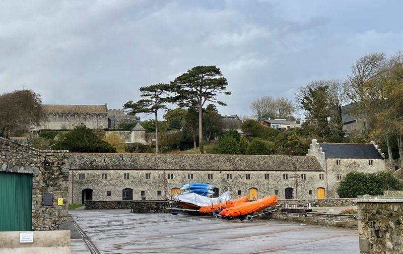
This building dates probably from the late C16 or early C17, and was built by Sir Edward Stradling (died 1609). The origin of their description as barracks is uncertain but Sir Edward, the local Commissioner of Array, was concerned with coastal security both against pirates and with the Spanish invasion scare in 1588. The Stradlings were also closely involved with the Royalist cause in South Wales during the Civil War and the building may have been converted to cavalry barracks at that period. They could also have been grand stables for the hunt at some time. They fell out of use, possibly with the death of the last Stradling owner in 1738, however, and they are not marked on the Tithe map of 1848 while the 1877 OS map shows them as ruins and a photograph in Country Life in 1907 shows them complete but roofless. They were restored by Randolph Hearst in the 1930s but his work was dismantled by Atlantic College who then had Alex Gordon and Partners rebuild them fully in C17 style and convert them to student accommodation in 1978-81.
Built of random local lias limestone with Welsh slate roofs and red ridge tiles. Two storeys, except for the west house, but set up at the east end and into the bank at the west end, the internal attic floors were added in 1980. A long east-west range with a shorter range projecting south at the west end. The central section was for communal living and there are houses, presumably for officers, attached at either end. The south elevation has seven segmentally arched stable doors interspersed with square leaded windows and two foot doors. The stable doors are either glazed or timbered apart from the first one from the left which is a through passage. There is a continuous range of nineteen 2-light leaded windows on the floor above and the second floor of the west house has another, as well as crow-stepped gables. The house at the north-east end has two storeys and possibly a basement. Its south elevation has a flight of steps rising from the south-west to the ground floor. Four-centred doorway with a 2-light mullioned window to each side. On the first floor, a 2-light window to each side of central single light window. High wall in front of ground floor; a further flight of steps rises north-east from right hand end of house. Crow-stepped gables.
The rear elevation of this house has a central wing with a crow-stepped gable. The main range has a timber pentice to the road with more 2-light windows above and a range of roof-lights. The west house has another projecting gable.
The south range has a terrace projecting forward on the courtyard side with a range of arched openings above. Segmental arch through to the stable yard behind, which has more segmental arched openings with single light windows above and more roof-lights. Almost all the features of the whole building are reproduction ones put in as a part of the 1980 restoration.
Only a very small portion of the interior was seen at resurvey. This was completely late C20 in character, and the history of the building suggests that most of the rest of the interiors will be the same. RCAHMW, however, records the surviving Tudor features, including some doorways and fireplaces as well as latrines etc.
Included for its special interest and group value as a part of St. Donat's Castle and its associated gardens and as a rare building type.
External links are from the relevant listing authority and, where applicable, Wikidata. Wikidata IDs may be related buildings as well as this specific building. If you want to add or update a link, you will need to do so by editing the Wikidata entry.


Other nearby listed buildings
