Approximate Location Map
Large Map »
Latitude: 51.7117 / 51°42'42"N
Longitude: -3.8176 / 3°49'3"W
OS Eastings: 274517
OS Northings: 203006
OS Grid: SN745030
Mapcode National: GBR H2.38H6
Mapcode Global: VH4JZ.S74M
Plus Code: 9C3RP56J+MX
Entry Name: Cefn Celfi
Listing Date: 22 May 1972
Last Amended: 16 December 2003
Grade: II
Source: Cadw
Source ID: 11193
Building Class: Domestic
ID on this website: 300011193
Location: Some 600m E of the centre of Rhos reached by a track off the A474 opposite Primrose Lane.
County: Neath Port Talbot
Town: Swansea
Community: Cilybebyll
Community: Cilybebyll
Locality: Rhos
Built-Up Area: Pontardawe
Traditional County: Glamorgan
Tagged with: House
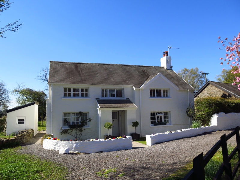
Much altered mid C17 minor gentry house with surviving interior features, the exterior remodelled 1951, and since listing in 1972. The core of the house is a hall with deep fireplace and corner winding stair entered from later porch, with narrow outer room to left. Added rear wing possibly C18. Cefn Celfi was built on Plas Cilybebyll land in the C17 by David ap John whose brother Griffith ap John married the heiress of Cilybebyll. In 1972 there were 2 small gables, and sash windows with intact glazing bars.
House, whitewashed rubble stone with slate roofs and small brick right end stack. Two storeys, three-window range. Wholly remodelled externally with C20 triple casement windows. Hall front wall to right is stepped slightly forward with triple casement each floor and shallow gable over upper window. To centre is entry in lean-to porch of rubble stone, triple casement above. To left is triple casement each floor. Right end wall has one upper window and a half-round bread-oven projection. Left end wall has wall-pier to right of demolished attached byre, triple casement each floor. Rear has casement pair to right and large wing to left with square rubble stone roof-slope chimney, triple casement each floor on end wall and front wall added C20 rendered lean-to, covering centre door of main house. Windowless rubble rear wall.
Interior not inspected, said to retain features noted in 1972. Ground floor hall with chamfered beam, run-out stops and reeded square joists, large fireplace with chamfered timber lintel and bread oven. Winding stone staircase entered via diagonally-set Tudor-arched doorway in corner to left of fireplace. Upper floor and roof had been renewed before 1972.
Included despite exterior rebuilding for the surviving C17 ground floor hall.
External links are from the relevant listing authority and, where applicable, Wikidata. Wikidata IDs may be related buildings as well as this specific building. If you want to add or update a link, you will need to do so by editing the Wikidata entry.


Other nearby listed buildings
