Approximate Location Map
Large Map »
Latitude: 52.2411 / 52°14'27"N
Longitude: -3.154 / 3°9'14"W
OS Eastings: 321298
OS Northings: 260952
OS Grid: SO212609
Mapcode National: GBR F0.0SC8
Mapcode Global: VH69K.8XYV
Plus Code: 9C4R6RRW+C9
Entry Name: Brookside Farmhouse
Listing Date: 29 April 1993
Last Amended: 29 April 1993
Grade: II
Source: Cadw
Source ID: 9229
Building Class: Domestic
ID on this website: 300009229
Location: Part of a substantial farm group sited at the E end of the High Street.
County: Powys
Community: New Radnor (Maesyfed)
Community: New Radnor
Traditional County: Radnorshire
Tagged with: Farmhouse
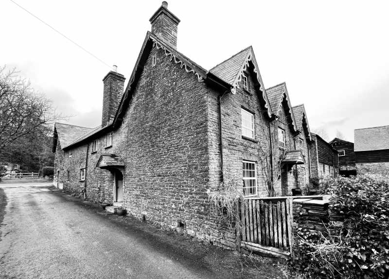
C16/17 in origin.
Timber-framed, refronted in rubble stone C19. Two storeys, L-plan house with adjoining granary wing at north end. South range has principal elevations in even coursed rubble blocks, 3 large eaves dormers, decorative openwork barge-boards. Slate roofs except for section of stone tiling on the yard side. Two rubble end stacks to south range, tall rubble lateral stack to west range. South front has central door, slated canopy porch, openings under flat voussoir heads, four-panel door and overlight; three-window range with replacement UPVC sash-type windows, two C19 dormer casements, central dormer has dressed stone recessed panel. On yardside of south range is exposed section of large panel timber-framing including a portion of chamfered window framing. The west range has a boarded door with slated canopy and C20 windows to the roadside, C19 and C20 casements under cambered heads to yardside.
Two front parlours with central hallway and straight-run stairs with thick, stick balusters and closed string. West range includes kitchen, back kitchen and dairy - exposed beams, some with scroll stops, flagstone floors, salting slab. Some timber-framing is exposed in partition walls. One six-panel door, mainly boarded doors with strap hinges. Room above dairy, reached by external steps and formerly used as wool room, has large chamfered beams and exposed joists.
Included for its importance in the village context, in spite of replacement windows.
External links are from the relevant listing authority and, where applicable, Wikidata. Wikidata IDs may be related buildings as well as this specific building. If you want to add or update a link, you will need to do so by editing the Wikidata entry.


Other nearby listed buildings
