History in Structure

Outbuilding Range to SW of Hay Castle

A Grade II Listed Building in Hay-on-Wye, Powys

More Photos »
Approximate Location Map
Large Map »

Coordinates

Latitude: 52.0738 / 52°4'25"N

Longitude: -3.1264 / 3°7'35"W

OS Eastings: 322891

OS Northings: 242313

OS Grid: SO228423

Mapcode National: GBR F1.CF3Y

Mapcode Global: VH6BJ.R4JK

Plus Code: 9C4R3VFF+GC

Entry Name: Outbuilding Range to SW of Hay Castle

Listing Date: 1 February 1988

Last Amended: 1 February 1988

Grade: II

Source: Cadw

Source ID: 7407

Building Class: Domestic

ID on this website: 300007407

Location: Immediately to SW of the Castle House attached by a lintel to a former doorway across the angle. Entered from the service courtyard opposite the former coach house and stable range.

County: Powys

Community: Hay (Y Gelli Gandryll)

Community: Hay

Built-Up Area: Hay-on-Wye

Traditional County: Brecknockshire

Tagged with: Appendage

Find accommodation in
Hay-on-Wye

History

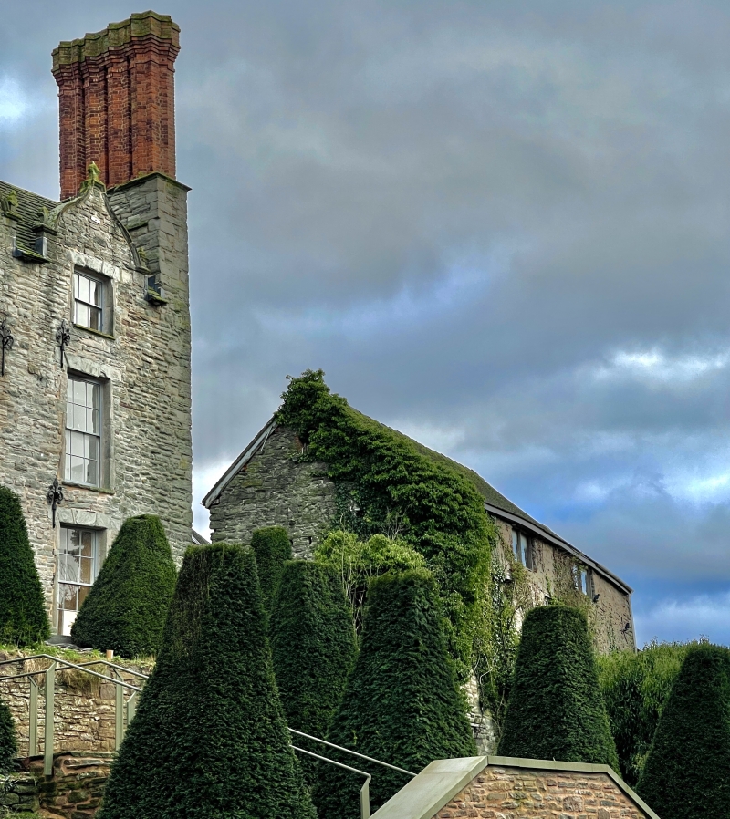
Probably C17 with C19 alterations.

Exterior

2-storey rubble range with boarded loft opening; partly re-roofed at time of inspection. Basement to the buttressed NW side overlooking Castle Street; 2-light openings. Blocked attic window with brick surround on NE gable. Attached single storey range at SW end with stone tile roof.

Reasons for Listing

Included for group value with Hay Castle.

External Links

External links are from the relevant listing authority and, where applicable, Wikidata. Wikidata IDs may be related buildings as well as this specific building. If you want to add or update a link, you will need to do so by editing the Wikidata entry.

Recommended Books

Other nearby listed buildings

  • II Former Coach-House & Stable Range to Hay Castle
    Attached to the SW end of the Castle House and splayed forward with the yard to rear; screened from the garden by a rubble wall, partly broken down.
  • II J.Geoffrey Aspin
    Set into a continuous row of street frontages stepped up from adjoining properties.
  • II Fine Fare
    Set back on the corner with Back Fold; No 27 adjoins forward to left. Formerly the Mason's Arms PH.
  • II Section of the Boundry Wall to Hay Castle
    Adjoining No 30 at SW end and continuing to the corner with the Market Place; set in the slope.
  • I Hay Castle
    Dominating the town with Back Fold, Castle Lane and Oxford Road bordering the castle grounds.
  • II H.R.Grant including former Flannel mill to rear
    Set into a row of street frontages, stepped up from the adjoining properties. The mill extends at an angle to rear set in the slope and end on to Belmont road.
  • II Hay & Cusop War Memorial
    At junction of Castle Lane and Castle Street, set into the wall of the castle grounds.
  • II Steve Davies Domestic Appliances
    Part of a small group towards the corner with Belmont Road, stepped down from No 6. No 8 was formerly the Dog Inn and later the Talbot Inn.

BritishListedBuildings.co.uk is an independent online resource and is not associated with any government department. All government data published here is used under licence. Please do not contact BritishListedBuildings.co.uk for any queries related to any individual listed building, planning permission related to listed buildings or the listing process itself.

British Listed Buildings is a Good Stuff website.