Approximate Location Map
Large Map »
Latitude: 51.8591 / 51°51'32"N
Longitude: -3.1396 / 3°8'22"W
OS Eastings: 321616
OS Northings: 218451
OS Grid: SO216184
Mapcode National: GBR F0.T3VN
Mapcode Global: VH6CH.JJLN
Plus Code: 9C3RVV56+J5
Entry Name: Churchyard boundary wall running from Gwyn Yr Afon to the entrance into the later Churchyard
Listing Date: 25 September 1986
Last Amended: 25 September 1986
Grade: II
Source: Cadw
Source ID: 7240
Building Class: Religious, Ritual and Funerary
ID on this website: 300007240
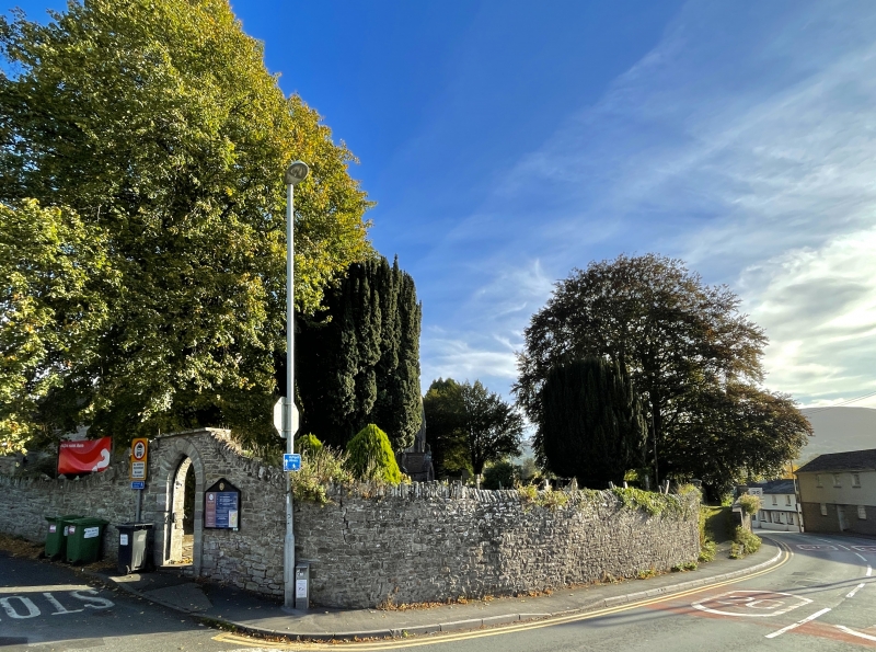
Location: Continuous stretch of rubble wall lining the road and acting as a revetment wall to the elevated churchyard, increasing slightly in height to N
County: Powys
Community: Crickhowell (Crughywel)
Community: Crickhowell
Built-Up Area: Crickhowell
Traditional County: Brecknockshire
Tagged with: Churchyard wall
Continuous stretch of rubble wall lining the road and acting as a revetment wall to the elevated churchyard, increasing slightly in height to N; curves around corner to W of Church and continues around E end beyond the lychgate to the entrance into the later churchyard.
Probably C18 pointed arched SW gateway with advanced architrave, corbelled parapet and keystone leading to steps up to footpath. Ramped walkway to left, set back, with further rubble wall in line with road; plain gate-piers with Gothic iron gates leading to path to W door. An undated view shows this section of wall much as it is today, its depiction of the original N aisle windows suggesting a pre circa 1765 date. Pointed copings beyond; curves around corner and rises to NW pointed arched entrance with keystone, dated 1843. Wall continues E along Silver Street, decreasing in height as ground rises; broken by opening opposite N transept. Turns S and runs along Church Lane to the freestone lychgate with stone tiled roof and arched trusses on massive corbels. Rubble wall continues to S; steps up and curves towards gate piers which are not of special interest.
Group value.
External links are from the relevant listing authority and, where applicable, Wikidata. Wikidata IDs may be related buildings as well as this specific building. If you want to add or update a link, you will need to do so by editing the Wikidata entry.


Other nearby listed buildings
