Approximate Location Map
Large Map »
Latitude: 55.9383 / 55°56'17"N
Longitude: -3.1919 / 3°11'30"W
OS Eastings: 325643
OS Northings: 672338
OS Grid: NT256723
Mapcode National: GBR 8NL.YR
Mapcode Global: WH6SL.YZ6Z
Plus Code: 9C7RWRQ5+86
Entry Name: 1, 2, 3 Roseneath Street, Edinburgh
Listing Name: 1-3 (Inclusive Numbers) Roseneath Street, Edinburgh
Listing Date: 15 January 1992
Last Amended: 17 July 2015
Category: B
Source: Historic Scotland
Source ID: 405414
Historic Scotland Designation Reference: LB30464
Building Class: Cultural
ID on this website: 200405414
Location: Edinburgh
County: Edinburgh
Town: Edinburgh
Electoral Ward: Morningside
Traditional County: Midlothian
Tagged with: Architectural structure
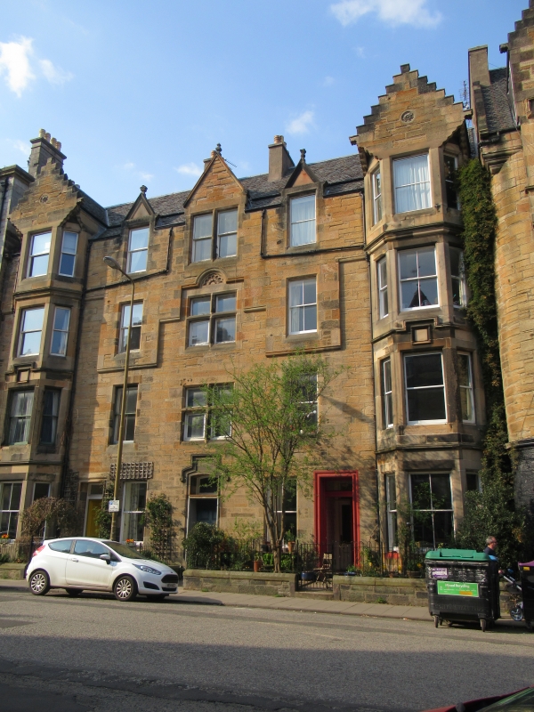
S (ENTRANCE) ELEVATION: central hoodmoulded doorway; doorways and single windows in bays to inner left and right; panelled doors; plate glass fanlights. Full-height canted windows in bays to outer left and right, corbelled to square at gableheads with inset floral paterae; dividing cornices; square blank tablets above 1st floor windows. Mullioned and transomed bipartite windows at 1st and 2nd floors in central bay; semi-circular floreate moulding above 2nd floor window; 3rd floor bipartite window breaking eaves in pedimented dormerhead. Single windows in remaining bays, 3rd floor windows breaking eaves in pedimented dormerheads.
4-pane and plate glass sash and case windows. Grey slate roof; lead flashing; rendered mutual stacks; moulded cans; beak skewputts.
INTERIOR: not seen 1990.
Low saddleback wall to street.
Forms continuous irregular terrace with 15-30 (inclusive nos) Argyle Place and 2-8 (even nos) Roseneath Terrace. Very similar to 5-9 Roseneath Terrace (see separate listing).
The period between 1860 and 1900 saw significant residential expansion in the city of Edinburgh with construction of a number of residential tenement suburbs.
The tenement suburb of Marchmont developed between circa 1876 and 1914
following the feuing of the Warrender family estate (land south of the Meadows).
Marchmont's development can be viewed in two distinct phases, with the first phase, prior to 1900, largely following the plan laid out by David Bryce of 1869. This phase, which saw the construction of streets in the north and east of the site, is characterised by the individual nature of the work by builders and architects who frequently developed only one or two feus at a time. These tenements were built predominantly in the baronial style following guidelines set down in the 1869 feu charter. In the second phase, after 1900, the baronial style recedes and elevations become more uniform.
Listed building record and statutory address updated (2015). Previously listed as '1-3 (inclusive nos) Roseneath Street'.
External links are from the relevant listing authority and, where applicable, Wikidata. Wikidata IDs may be related buildings as well as this specific building. If you want to add or update a link, you will need to do so by editing the Wikidata entry.


Other nearby listed buildings
