Approximate Location Map
Large Map »
Latitude: 53.6707 / 53°40'14"N
Longitude: -1.6777 / 1°40'39"W
OS Eastings: 421392
OS Northings: 419403
OS Grid: SE213194
Mapcode National: GBR JTQZ.LX
Mapcode Global: WHC9X.6ZCW
Plus Code: 9C5WM8CC+7W
Entry Name: Railway viaduct MVN2/196, Wheatley's Bridge
Listing Date: 23 March 2018
Grade: II
Source: Historic England
Source ID: 1450703
Also known as: Railway Viaduct MVN2/196
ID on this website: 101450703
Location: Sands, Kirklees, West Yorkshire, WF14
County: Kirklees
Civil Parish: Mirfield
Traditional County: Yorkshire
Lieutenancy Area (Ceremonial County): West Yorkshire
Tagged with: Architectural structure Railway viaduct
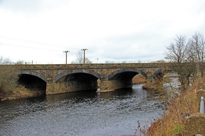
Railway skew bridge, 1836-1839 with widening of 1884, by George Stephenson and Thomas Gooch for the Manchester and Leeds Railway.
Railway skew bridge, 1836-1839 with widening of 1884, by George Stephenson and Thomas Gooch for the Manchester and Leeds Railway.
MATERIALS: gritstone and blue engineering brick.
DESCRIPTION: spanning the River Calder and visible along a considerable length of Steanard Lane which runs along the eastern bank here.
The bridge runs east-west and has five segmental-arched skewed spans. The western end is flanked by curved and canted wing walls, with ashlar coping stones, modern two-rail tubular metal handrails and terminating in low stone piers with capstones. The eastern end splays slightly. The river piers are battered and have bull-nosed ends which rise above the springing points with two dressed courses and a three-course ashlar terminal comprising a projecting lower course with lower roll moulding, and two stepping courses. Full-height three-faceted piers stand on both faces on either bank, with stepped pyramidal caps. The abutments, spandrels and parapets are built of coursed, quarry-faced rusticated gritstone. Both faces have a projecting ashlar band above the arches and continuing across the bank piers, and three-course parapet with ashlar copings.
The northern arches are of tooled stone blocks rising directly off the piers and have tooled, keyed ashlar voussoirs. The southern arches are of seven courses of blue engineering brick with a stone roll moulding above the exposed headers of the ring. These arches spring from a saw-tooth course of stone impost blocks along the top of each pier.
The eastern abutment of Wheatley’s Bridge is also faced with coursed, quarry-faced rusticated gritstone, with rounded angles. The box-girder bridge to the east rests on a modern concrete footing which is let into the top of the abutment.
In contrast to the main trunk lines of the late 1830s that were constructed by single railway companies the route from Stalybridge to Leeds had fragmented origins and was the work of three different railway companies: the Huddersfield & Manchester Railway, Leeds, Dewsbury & Manchester Railway, and the Manchester & Leeds Railway.
The Huddersfield & Manchester Railway was authorised in 1845 and followed the route of the Huddersfield Narrow Canal for much of its length, including a railway tunnel through the Pennine hills set alongside the earlier Standedge Canal Company tunnel of 1811; in 1846 the railway company also acquired the canal. Joseph Locke and Alfred Stanistreet Jee were appointed to survey and design the new line, the two engineers having already worked together on a major project linking Manchester and Sheffield. Jee became the lead engineer for the Huddersfield line, which passed through challenging terrain, assisted by resident engineers that included his brother Moreland Jee (until 1848) and Herbert F Mackworth. Construction of the line was divided into various contracts, with many contractors being only responsible for a single cutting, viaduct or tunnel portal. The largest contract for the Standedge Tunnel between Diggle and Marsden was let to a single contractor, Thomas Nicholson in 1847. The tunnel's completion in 1849 marked the opening of the line.
The Leeds end of the route, which was also authorised in 1845, was constructed by the Leeds, Dewsbury & Manchester Railway. The engineer was Thomas Grainger who had previously largely worked in Scotland, and the line was completed in 1849.
A short three-mile section of the route between Heaton Lodge Junction and Thornhill Junction near Mirfield was developed by the Manchester & Leeds Railway and was constructed between 1837 and 1840, with George Stephenson as the chief engineer. The structures on this line were designed by Thomas Gooch under the oversight of Stephenson. In 1847 the railway company changed its name to the Lancashire & Yorkshire Railway (LYR).
In 1847 the Huddersfield & Manchester Railway and the Leeds, Dewsbury & Manchester Railway were acquired by the London & North Western Railway (LNWR) so that the company could access the city of Leeds and the textile towns of West Yorkshire. This pitted them as rivals to the Lancashire & Yorkshire Railway, although at points on the route the two companies had to work together. By 1851 the London & North Western Railway had an overall mileage of railway track of 800 miles and it became the most prominent railway company in the country and the largest joint-stock concern in the world in the late C19. Although the LNWR had a general manager, Captain Mark Huish, the lines of the Stalybridge to Leeds route still managed their own affairs. LNWR later carried out expansion works, including the widening of tracks and bridges, the construction of additional tunnels, and station alterations. In 1923 the line became part of the London Midland & Scottish Railway, and subsequently part of the nationalised British Railways in 1948. The line, its structures and track are currently (2018) owned by Network Rail, and the passenger services operated by TransPennine Express and Northern Rail.
This bridge was built to carry the railway over the River Calder to the east of Mirfield Station. It was designed by George Stephenson and Thomas Gooch and dates from 1836 to 1839. It is very similar in design to the Mirfield viaduct (National Heritage List for England (‘List’) entry 1313676) approximately a kilometre to the west, west of Mirfield Station; that viaduct carries the railway over the western loop of the same meander of the river. Wheatley's Bridge was widened from two to four tracks by an addition on its southern side by the LYR in 1884. The addition matched the walling and bull-nosed piers of the original, but used blue engineering brick rather than stone for the arches. The adjacent bridge to the east (MVN2/197 Steanard Lane) has a replacement box-girder deck which rests on, and required slight lowering of, the eastern abutment of this bridge.
Wheatley's Bridge (MVN2/196), built 1836-1839 by George Stephenson and Thomas Gooch for the Manchester and Leeds Railway, and widened by the Lancashire and Yorkshire Railway in 1884, is listed at Grade II for the following principal reasons:
Historic interest:
* constructed during the pioneering age of railway building and a good example of an 1830s skew bridge on what is now one of the main railway lines in northern England;
* associated with the notable railway engineer George Stephenson;
* the widening of the bridge illustrates the late-C19 growth in railway traffic.
Architectural interest:
* the bridge is well-detailed with curving wing walls, abutment piers, stepped caps to the river piers, string band and keyed voussoirs that lift its design above the purely functional;
* retaining the majority of its original design features and fabric and sympathetically widened with similar levels of craftsmanship and detailing to the original.
Group value:
* with the other listed structures designed by George Stephenson and Thomas Gooch on the former Manchester and Leeds Railway, in particular the Mirfield viaduct.
External links are from the relevant listing authority and, where applicable, Wikidata. Wikidata IDs may be related buildings as well as this specific building. If you want to add or update a link, you will need to do so by editing the Wikidata entry.


Other nearby listed buildings