Approximate Location Map
Large Map »
Latitude: 53.4576 / 53°27'27"N
Longitude: -1.4928 / 1°29'34"W
OS Eastings: 433775
OS Northings: 395766
OS Grid: SK337957
Mapcode National: GBR LX0G.M8
Mapcode Global: WHDD9.1CF6
Plus Code: 9C5WFG54+2V
Entry Name: West and North Barns, Barnes Hall Farm
Listing Date: 25 February 2013
Grade: II
Source: Historic England
Source ID: 1413933
ID on this website: 101413933
Location: Wood Seats, Sheffield, South Yorkshire, S35
County: Sheffield
Civil Parish: Ecclesfield
Built-Up Area: Chapeltown
Traditional County: Yorkshire
Lieutenancy Area (Ceremonial County): South Yorkshire
Church of England Parish: Chapeltown St John the Baptist
Church of England Diocese: Sheffield
Tagged with: Architectural structure
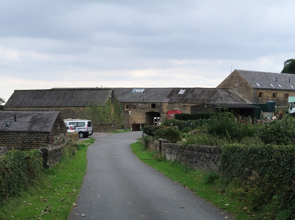
Two barns in a farm complex. C16 or C17, and c1824 with later-C19 alterations. Earlier barn originally built for the Watts Horton family, later barn built in early-C19 for planned farm for William Smith. Sandstone, stone slates, corrugated asbestos, timber framing.
Two barns for farm complex. C16 or C17, and c1824 with later-C19 alterations. Earlier barn built for the Watts Horton family, later barn built for early-C19 planned farm for William Smith. Sandstone, stone slates, corrugated asbestos, timber framing.
PLAN: a courtyard farm complex incorporating an earlier, timber-framed threshing barn on the west side, encased in stone and extended in the early C19 to provide a mixed-use building. On the north side is a stone-built threshing barn dated 1824 with an enclosed cart entrance into the yard at its west end and later-C19 alterations at the east end to form a food processing room
Also forming part of the courtyard plan are an angled corner building connecting the west and north barns, an early-C19 single-storey west range for animals with an enclosed pedestrian walkway between the yard and the hall drive, and a long, west range of single-storey open-fronted shelter sheds. These buildings are not of special interest in the national context.
The south side of the yard is formed by the high north wall of the walled garden to the immediate south; towards the south-west corner is a dovecote (Grade II), which may have originally have been intended as a gazebo for the garden, and a cartshed (Grade II) is situated to the north of the courtyard and parallel to the north barn.
EXTERIOR:
West barn: externally the barn is built of squared, punched sandstone blocks laid in watershot courses. The roof is covered in corrugated asbestos and is double-pitched with an extended catslide roof on the east, yard side; the roof on the west side overhangs the stone wall and is supported on a horizontal timber plate on projecting rafters. The outer, rear elevation stands to the immediate east side of the hall drive and has five bays with square windows on the ground and first-floor levels. The window apertures have ashlar surrounds, flush on the first floor and with projecting sills on the ground floor. The ground-floor windows have glazed small-pane frames, some partially opening, with wooden, hinged shutters to the first-floor windows. Between the first and second bays is an inserted doorway with a plain boarded, hinged door. The east, yard elevation is single storey in height and of six bays. The three left-hand bays are a milking parlour and have equally-spaced doorways with ashlar lintels and large quoins to the jambs. The three right-hand bays are a stable and have a wider central doorway flanked by square windows with ashlar surrounds. The doorways have split doors and the windows have glazed small-pane frames with tilting top lights. Along the front of the building is a cobbled, stone kerbed walkway.
North barn: the barn is built of squared, punched sandstone blocks laid in watershot courses, with a stone slate roof hipped at the east end, and a single bay at the west end roofed in corrugated asbestos as a continuation of the north-west corner building, though there is a straight joint between the two. The outer, north elevation has a large, segmental-headed cart entrance towards the left-hand end with large quoins to the jambs, stone voussoirs, and large, boarded double doors. At the far right-hand end is a pair of smaller cart entrances with basket arches and boarded double doors. The left-hand entrance has bumper stones and leads through into the yard; the right-hand entrance opens into a separate, altered room. To the left of the large cart entrance is a pedestrian doorway with quoin jambs, monolithic lintel, and boarded door, and a small, ground-floor window later extended in depth. Above and to the right are rows of slit vents. Either side is an inserted square window with small-pane glazed frame. Beneath the eaves at the right-hand end are three square pitching holes. The south, yard elevation has a similarly detailed basket arch entrance at the left-hand end and large, segmental-arched cart entrance towards the right-hand end. Between are slit vents and to the right of the large cart entrance is a pedestrian doorway (beneath the attached shelter shed), with a rectangular window with ashlar surround and small-pane timber frame above the roof level of the shelter shed. The left-hand bay has been truncated, and a recessed wall rebuilt which relates more to the corner building. Along the front of the building is a stone kerbed walkway.
INTERIOR:
West barn: internally the barn comprises five bays and was initially narrower with a timber frame before being later encased in stone. On the east, yard side of the building there remain two vertical posts defining the first and second bays. The large, square posts rise to a wall plate, with diagonal braces to each side and a third diagonal brace supporting tie beams of principal rafters with collars, pegged and numbered with roman numerals. Empty mortices in the tie beams indicate that there were originally similar braced posts on the west side of the building, but the tie beams now sit on sections of sawn-off wall plate set in the stone wall. The two right-hand vertical posts have been partially replaced by a stone wall, with only the upper sections with braces supporting the tie beams remaining. The trusses have two purlins to each side and a ridge post. Horizontal mid-rails run between the south gable wall and the two full-height vertical posts; that running between the second post and the replacement stone wall is a later insertion. The third bay was originally a double-height central opening indicative of a threshing barn. Empty mortices in the wall plate and mid rails indicate the position of timber studs that would have supported lath and plaster to the original outer walls. On the east side of the vertical posts is a C19 aisle with half-trusses supporting the lower part of the catslide roof. The trusses on the left-hand side rest on the original mid-rails, while those on the right-hand side are set into the later stone wall. The trusses have two vertical and two diagonal struts and are morticed. They support two tusked, tenoned purlins. The left-hand side has a full-depth milking parlour with a row of stalls on each side of a central feeding passage. The stalls are concrete but the arrangement respects the door positions. The space on the right-hand side is sub-divided by stone walls. On the east, yard side is a plastered stable with timber and brick stall dividers against the rear wall, a tiled floor, and partial remains of a hay rack. Behind the rear wall is a separate feeding passage with several square openings to enable hay to be put into racks; some have wooden hinged shutters and others have been blocked. On the west side is a stone-flagged room into which the inserted doorway opens. The first floor is reached by a narrow wooden ladder in the feeding passage (not inspected).
North barn: the barn is of eleven internal bays with king post trusses with vertical and diagonal struts similar in appearance to the half-trusses in the west barn. The king post is bolted with tusked tenoned purlins. There is a stone-flagged threshing floor between the large cart entrances towards the east end of the building. On its east side is a ceiled room for food preparation. At the west end the cart entrance into the yard has a stone side wall and is ceiled to form a separate, cobbled, passage.
The single-storey west range, north-west corner building, and east shelter shed are not included in this designation.
The Barnes Hall estate was owned by the Watts Horton family from C16, with the original hall perhaps dating from the C15. In 1823 the estate was purchased by Mr William Smith, who demolished the original hall and built the present hall around 1824 (listed Grade II). In the later C20 the farm was farmed by three generations of the same family.
Though much of the complex has a visual homogeneity suggestive of an early C19 planned farm, the physical evidence of the buildings indicates that the cartshed and west barn both incorporate timber framing indicative of an earlier construction date, perhaps as early as the C16 or C17. The large north barn has an 1824 datestone and it is apparent that William Smith not only rebuilt the hall, but also redesigned the complex as a planned farmstead, encasing some of the earlier buildings in stone.
The farm is shown on an Enclosure Awards map of 1788 by William Fairbank. Though the scale is small, several buildings are shown including two parallel buildings on the north side of the yard, the northernmost building equating to the listed cartshed. The listed dovecote is also shown, as is a building on the west side of the yard and the original hall. By 1855 the first edition 1:10560 Ordnance Survey map shows a complex set around a roughly square yard, with ranges of buildings on three sides, as at present; the new hall and associated stable block are also present. The 1892 1:2500 Ordnance Survey map clearly shows the present buildings, and also that the yard had been sub-divided into four smaller enclosures, indicating an emphasis upon livestock by this date.
The farm is no longer in use as an agricultural complex.
The west barn and north barn at Barnes Hall Farm, of C16/C17 date and c1824 are designated at Grade II for the following principal reasons:
* Date: the stone west barn encases a five-bay timber-framed threshing barn of a C16 or C17 date, which is a rare survival both in terms of date and because the majority of similarly dated barns in this area originated as cruck barns rather than box-framed structures;
* Historic Interest: the original timber-framed west barn, and an associated cartshed (Grade II), indicate an arable farm, while the c1824 development of a planned complex demonstrates a clear investment by the new landowner and shows a move to a mixed farm with the west barn extended and adapted to use for animals, and the construction of a new large threshing barn on the north side of the yard;
* Architectural Interest: there is a uniformity of treatment to the exterior of both barns, with high-quality workmanship and attention to detail shown in the use of shaped, punched, and regularly coursed stonework, quoined doorways, and ashlar window surrounds; the regional character of the buildings is emphasized by laying the stone in watershot courses, with the blocks slightly angled outwards at the top to encourage the runoff of water, a technique found in northern Pennine districts;
* Interior: the west barn has a significant proportion of an earlier post and truss structure including wall posts, braces, and principal rafter trusses, with early- C19 half trusses to the east-side extension which are similar to the form to the king-post trusses used in the north barn, both having vertical and diagonal struts. The north barn retains is stone flag threshing floor;
* Group Value: the west barn and north barn have group value with the adjacent cartshed, the dovecote standing in the south-west corner of the farmyard, and the nearby Barnes Hall, all listed at Grade II.
External links are from the relevant listing authority and, where applicable, Wikidata. Wikidata IDs may be related buildings as well as this specific building. If you want to add or update a link, you will need to do so by editing the Wikidata entry.


Other nearby listed buildings
