Approximate Location Map
Large Map »
Latitude: 52.3677 / 52°22'3"N
Longitude: -2.7199 / 2°43'11"W
OS Eastings: 351078
OS Northings: 274651
OS Grid: SO510746
Mapcode National: GBR BK.RYYD
Mapcode Global: VH843.SRY8
Plus Code: 9C4V979J+32
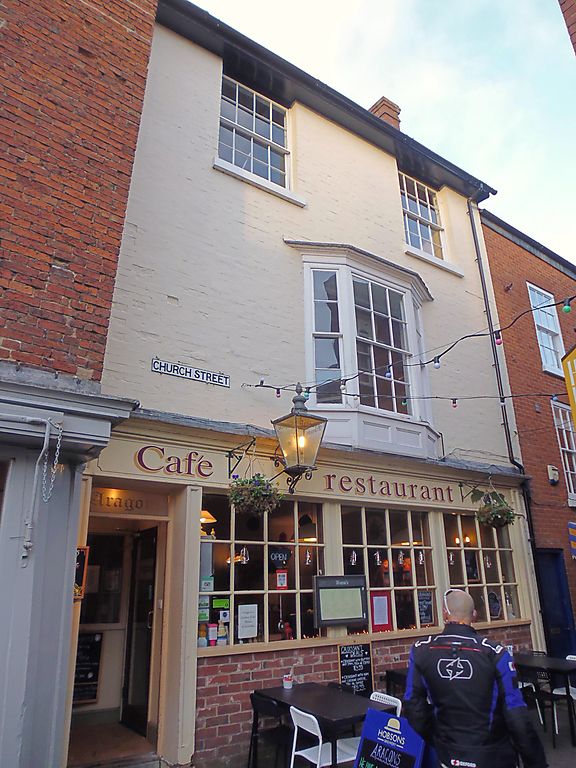
Entry Name: 5, Church Street
Listing Date: 28 October 1969
Grade: II
Source: Historic England
Source ID: 1281991
English Heritage Legacy ID: 389837
ID on this website: 101281991
Location: Ludlow, Shropshire, SY8
County: Shropshire
Civil Parish: Ludlow
Built-Up Area: Ludlow
Traditional County: Shropshire
Lieutenancy Area (Ceremonial County): Shropshire
Church of England Parish: Ludlow St Laurence
Church of England Diocese: Hereford
Tagged with: Restaurant Building
LUDLOW
SO5174 CHURCH STREET
825-1/1/213 No.5
28/10/69
GV II
House, now restaurant and dwelling. Early C19. Brick; slate
roof; brick end stack. 3-storeys and cellar; single-window
range: canted bay with 2/2: 6/6: 2/2 sashes under moulded
cornice; recessed 8/8 sashes over; late C19 shopfront: C20
door and glazing bars, original fasciaboard and cornice. C19
fenestration to rear.
Listing NGR: SO5107874651
External links are from the relevant listing authority and, where applicable, Wikidata. Wikidata IDs may be related buildings as well as this specific building. If you want to add or update a link, you will need to do so by editing the Wikidata entry.


Other nearby listed buildings
