Approximate Location Map
Large Map »
Latitude: 51.2814 / 51°16'53"N
Longitude: 1.0817 / 1°4'54"E
OS Eastings: 615011
OS Northings: 158098
OS Grid: TR150580
Mapcode National: GBR TY2.Q8V
Mapcode Global: VHLGM.P1QZ
Plus Code: 9F3373JJ+HM
Entry Name: 22, Palace Street
Listing Date: 3 May 1967
Grade: II
Source: Historic England
Source ID: 1260475
English Heritage Legacy ID: 440508
ID on this website: 101260475
Location: Canterbury, Kent, CT1
County: Kent
District: Canterbury
Electoral Ward/Division: Westgate
Parish: Non Civil Parish
Built-Up Area: Canterbury
Traditional County: Kent
Lieutenancy Area (Ceremonial County): Kent
Tagged with: Building
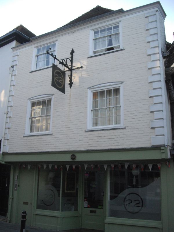
1.
944 PALACE STREET
(West Side)
No 22
TR 1558 SW 3/284 3.5.67.
II GV
2.
A timber-framed building refaced. 3 storeys painted brick, Hipped old toed
roof. Moulded wooden eaves cornice and end quoins. 2 sashes with verticals
only. Overhang. C19 shop front with pilasters. Interior beams.
Church of St Alpehege and Nos 10 to 28 (consec) form a group.
Listing NGR: TR1500758098
External links are from the relevant listing authority and, where applicable, Wikidata. Wikidata IDs may be related buildings as well as this specific building. If you want to add or update a link, you will need to do so by editing the Wikidata entry.


Other nearby listed buildings
