Approximate Location Map
Large Map »
Latitude: 53.6826 / 53°40'57"N
Longitude: -1.4988 / 1°29'55"W
OS Eastings: 433201
OS Northings: 420798
OS Grid: SE332207
Mapcode National: GBR KTZV.9M
Mapcode Global: WHC9Z.YPGQ
Plus Code: 9C5WMGM2+2F
Entry Name: 24-28, Westgate
Listing Date: 1 February 1979
Grade: II
Source: Historic England
Source ID: 1258725
English Heritage Legacy ID: 445565
ID on this website: 101258725
Location: Wakefield, West Yorkshire, WF1
County: Wakefield
Electoral Ward/Division: Wakefield North
Parish: Non Civil Parish
Built-Up Area: Wakefield
Traditional County: Yorkshire
Lieutenancy Area (Ceremonial County): West Yorkshire
Church of England Parish: Wakefield All Saints
Church of England Diocese: Leeds
Tagged with: Building
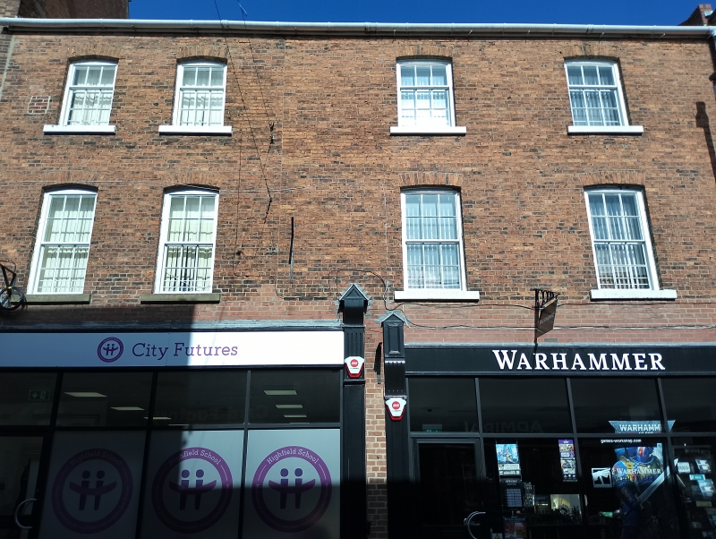
1. WESTGATE
5115 (North Side)
Nos 24 to 28 (even)
SE 3320 NW 2/257
GV
II
2.
Mid C19 terrace; 3-storeys, four windows in all, irregular. Light red brick;
stone flagged roof of moderate pitch. Cambered arches and stone cills to sash
windows with glazing bars. Modern shops below.
Listing NGR: SE3320120797
External links are from the relevant listing authority and, where applicable, Wikidata. Wikidata IDs may be related buildings as well as this specific building. If you want to add or update a link, you will need to do so by editing the Wikidata entry.


Other nearby listed buildings
