Approximate Location Map
Large Map »
Latitude: 53.1622 / 53°9'43"N
Longitude: -1.5893 / 1°35'21"W
OS Eastings: 427555
OS Northings: 362867
OS Grid: SK275628
Mapcode National: GBR 58H.M0Z
Mapcode Global: WHCDG.KSD4
Plus Code: 9C5W5C66+V7
Entry Name: Mile Post 4 Miles from Matlock
Listing Date: 26 October 1972
Grade: II
Source: Historic England
Source ID: 1247896
English Heritage Legacy ID: 429302
ID on this website: 101247896
Location: Darley Dale, Derbyshire Dales, Derbyshire, DE4
County: Derbyshire
District: Derbyshire Dales
Civil Parish: Darley Dale
Built-Up Area: Matlock
Traditional County: Derbyshire
Lieutenancy Area (Ceremonial County): Derbyshire
Church of England Parish: Darley St Helen
Church of England Diocese: Derby
Tagged with: Milestone
1. DALE ROAD NORTH
1390 DARLEY DALE
---------------
Mile Post 4 miles
from Matlock
SK 26 SE 10/88
II
2.
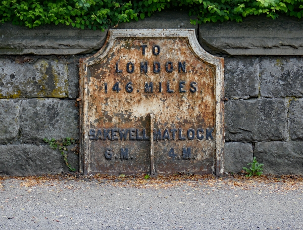
Early C19. A painted cast iron plate with shaped top and lettered "To
London 146 miles; Bakewell 6m; Matlock 4m".
Listing NGR: SK2755662866
External links are from the relevant listing authority and, where applicable, Wikidata. Wikidata IDs may be related buildings as well as this specific building. If you want to add or update a link, you will need to do so by editing the Wikidata entry.


Other nearby listed buildings
