Approximate Location Map
Large Map »
Latitude: 53.6131 / 53°36'47"N
Longitude: -1.9029 / 1°54'10"W
OS Eastings: 406522
OS Northings: 412956
OS Grid: SE065129
Mapcode National: GBR HV4N.TJ
Mapcode Global: WHB91.RF2Z
Plus Code: 9C5WJ37W+6R
Entry Name: Home Head Farm
Listing Date: 11 July 1985
Grade: II
Source: Historic England
Source ID: 1225001
English Heritage Legacy ID: 421225
ID on this website: 101225001
Location: Lingards Wood, Kirklees, West Yorkshire, HD7
County: Kirklees
Electoral Ward/Division: Colne Valley
Parish: Non Civil Parish
Traditional County: Yorkshire
Lieutenancy Area (Ceremonial County): West Yorkshire
Church of England Parish: Slaithwaite with East Scammonden St James
Church of England Diocese: Leeds
Tagged with: Agricultural structure
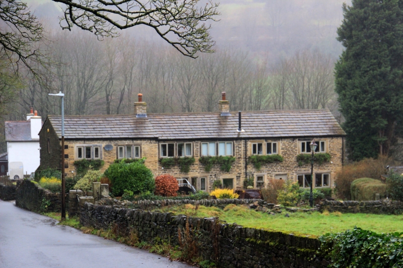
SE 01 SE WEST SLAITHWAITE ROAD
Slaithwaite
5/508
Home Head Farm
-
- II
Late C18 with later alterations. Terrace. Hammer dressed stone. Quoins.
Pitched stone slate roof (bitumen covered). 2 stacks (one with tabling).
2 storeys. South East elevation has: Ground floor; Entrances with stone surround.
Two 4-light stone mullioned window (each with 2 mullions removed). One 2-
light stone mullioned window (mullion removed) (some rebuilding). Small lean-
to extension (single storey). First floor; Various 3 and 4-light stone mullioned
windows (some mullions removed). North West elevation has: Ground floor;
Single storey lean-to extension. Large doorway to former barn (north end)
with segmental arched head (part blocked with single light window). Two 4-
light stone mullioned windows (each with 2 mullions removed and some rebuilding).
First floor; Three 4-light stone mullioned windows (each with 2 mullions removed);
One 3-light stone mullioned window (1 light blocked and 1 mullion removed).
Later single light.
Listing NGR: SE0652212956
External links are from the relevant listing authority and, where applicable, Wikidata. Wikidata IDs may be related buildings as well as this specific building. If you want to add or update a link, you will need to do so by editing the Wikidata entry.


Other nearby listed buildings
