Approximate Location Map
Large Map »
Latitude: 51.512 / 51°30'43"N
Longitude: -0.126 / 0°7'33"W
OS Eastings: 530137
OS Northings: 180897
OS Grid: TQ301808
Mapcode National: GBR HD.V4
Mapcode Global: VHGQZ.R8Q7
Plus Code: 9C3XGV6F+RH
Entry Name: Stanford's
Listing Date: 15 January 1973
Grade: II
Source: Historic England
Source ID: 1222308
English Heritage Legacy ID: 414454
Also known as: 12-14 Long Acre and 27A Floral Street
ID on this website: 101222308
Location: Strand, Westminster, London, WC2E
County: London
District: City of Westminster
Electoral Ward/Division: St James's
Parish: Non Civil Parish
Built-Up Area: City of Westminster
Traditional County: Middlesex
Lieutenancy Area (Ceremonial County): Greater London
Church of England Parish: St Martin-in-the-Fields
Church of England Diocese: London
Tagged with: Commercial building Office building Retail building
TQ 3080 NW CITY OF WESTMINSTER LONG ACRE, WC2
72/15
15.1.73 Nos, 12 to 14 consec.
(Stanford's) (Including
No. 27A Floral Street)
- II
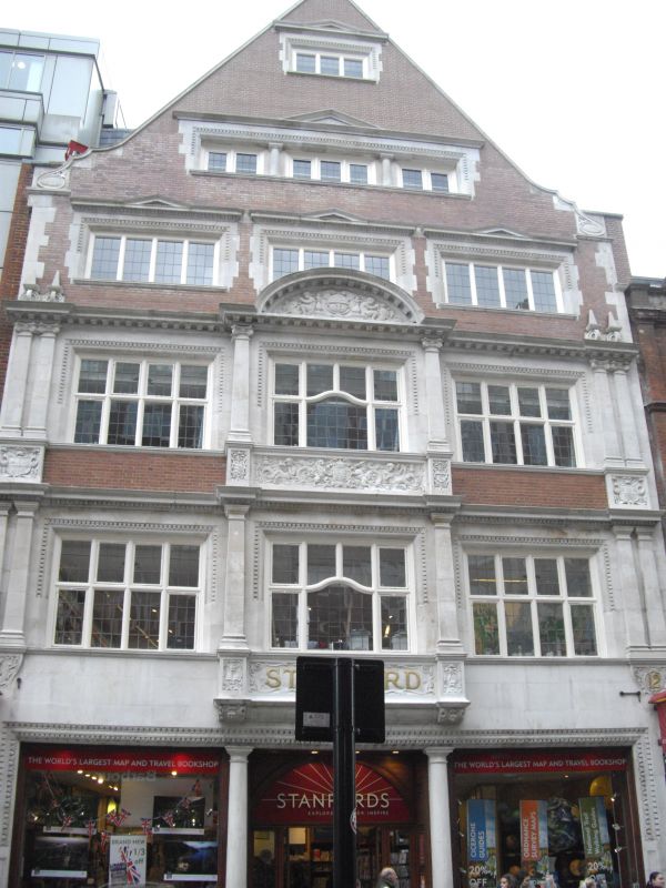
Office-commercial premises. c.1900-01 by Herbert Read and Macdonald. Red
brick with stone dressings and stone faced ground and 1st floors. Eclectic
Flemish Renaissance style. 4 storeys and attic in crowning gable. 3
windows wide broad front. Ground floor has double shop front with central
entrance flanked by engaged Doric columns and enriched architrave display
windows, under entablature. Upper floor windows principally 4-light leaded
casements with enriched stone surrounds, mullions and transoms; the 1st and
2nd floors respectively with paired pilasters and quoins and with central
window bay projecting and finished off with semi-elliptical pediment with
reliefs in tympanum (globe flanked by putti with cartouche inscribed
"E.D. 1900"), enriched aprons inscribed "STANFORD" on 1st floor and with
Royal Coat of Arms to that of 2nd floor. Attic storey framed and crowned
by stone dressed Dutch gable. The block extends back to Floral Street
where there is a plain warehouse elevation.
Listing NGR: TQ3014080886
External links are from the relevant listing authority and, where applicable, Wikidata. Wikidata IDs may be related buildings as well as this specific building. If you want to add or update a link, you will need to do so by editing the Wikidata entry.


Other nearby listed buildings
