Approximate Location Map
Large Map »
Latitude: 51.3692 / 51°22'9"N
Longitude: 0.2137 / 0°12'49"E
OS Eastings: 554191
OS Northings: 165672
OS Grid: TQ541656
Mapcode National: GBR TT.JK6
Mapcode Global: VHHP6.NVB8
Plus Code: 9F329697+MF
Entry Name: Eynsford House
Listing Date: 22 October 1982
Grade: II
Source: Historic England
Source ID: 1217170
English Heritage Legacy ID: 411966
ID on this website: 101217170
Location: Eynsford, Sevenoaks, Kent, DA4
County: Kent
District: Sevenoaks
Civil Parish: Eynsford
Built-Up Area: Eynsford
Traditional County: Kent
Lieutenancy Area (Ceremonial County): Kent
Church of England Parish: Eynsford St Martin
Church of England Diocese: Rochester
Tagged with: House
EYNSFORD HIGH STREET
1.
5280 (north-west side)
TQ 5465 12/55 Eynsford House
II
GV
2.
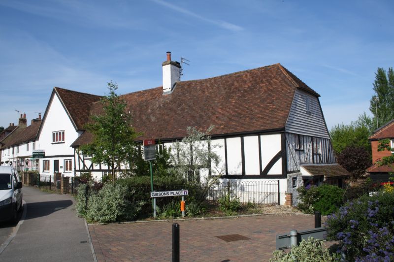
C17 or earlier timber-framed house. Two storeys stuccoed. First floor has some
exposed framing with diagonal braces. Left side gable. Four altered casements.
C17 brick chimney stack. Half-hipped gable.
Listing NGR: TQ5419165674
External links are from the relevant listing authority and, where applicable, Wikidata. Wikidata IDs may be related buildings as well as this specific building. If you want to add or update a link, you will need to do so by editing the Wikidata entry.


Other nearby listed buildings
