Approximate Location Map
Large Map »
Latitude: 51.4534 / 51°27'12"N
Longitude: -2.5897 / 2°35'22"W
OS Eastings: 359122
OS Northings: 172882
OS Grid: ST591728
Mapcode National: GBR C9K.8T
Mapcode Global: VH88N.2Q9N
Plus Code: 9C3VFC36+94
Entry Name: 3-10, Bath Street
Listing Date: 6 June 1975
Last Amended: 30 December 1994
Grade: II
Source: Historic England
Source ID: 1201990
English Heritage Legacy ID: 378923
ID on this website: 101201990
Location: Box Makers Yard, Bristol, BS1
County: City of Bristol
Electoral Ward/Division: Central
Parish: Non Civil Parish
Built-Up Area: Bristol
Traditional County: Somerset
Lieutenancy Area (Ceremonial County): Bristol
Church of England Parish: Bedminster
Church of England Diocese: Bristol
Tagged with: Building
BRISTOL
ST5972
901-1/42/1
06/06/75
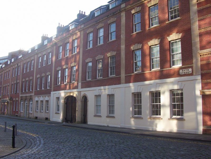
BATH STREET
(South side)
Nos.3-10 (Consecutive)
(Formerly Listed as:
BATH STREET
(South side)
Nos.6-17 (Consecutive)
Offices of Courage's Brewery)
GV
II
Terrace of 8 houses. c1792. By Thomas Paty and sons. Restored
c1980. Brick with ashlar dressings, brick stacks and pantile
mansard roofs. Double-depth plan.
Pilasters divide the terrace, with a sill band, moulded
cornice and parapet; C20 6/6-pane sash windows under cambered
heads with 7 stepped voussoirs and 2 dormers; varied ground
floors: Nos 8 & 10 have steeply pedimented doorcases on fluted
brackets, and interlaced overlights; No.9 has a pedimented
doorcase with a fan and C20 infilling; No.7 has elliptical
arched windows flanking a semicircular-arched window with
scrolled keys, set in a rusticated ashlar ground floor; No.6
has a C20 scribed rendered front; Nos 5 & 4 have a wide C20
opening across the party wall, and No.3 has 3 ground-floor
sashes and no second floor. INTERIORS extensively modernised.
HISTORICAL NOTE: the only remaining street row of the Patys'
Bridge Street development, part of the Corporation's post-1766
rebuilding of the city centre. Shown meeting St Thomas Street,
before being cut off by the development of Victoria Street, by
Loxton.
(Gomme A, Jenner M, Little B: Bristol, an Architectural
History: London: 1979-: 210; Loxton: Bristol: 1870-).
Listing NGR: ST5912272882
External links are from the relevant listing authority and, where applicable, Wikidata. Wikidata IDs may be related buildings as well as this specific building. If you want to add or update a link, you will need to do so by editing the Wikidata entry.


Other nearby listed buildings
