Approximate Location Map
Large Map »
Latitude: 54.8359 / 54°50'9"N
Longitude: -1.8522 / 1°51'7"W
OS Eastings: 409590
OS Northings: 549013
OS Grid: NZ095490
Mapcode National: GBR HDHJ.S8
Mapcode Global: WHC46.JQ64
Plus Code: 9C6WR4PX+84
Entry Name: Hownes Gill Viaduct
Listing Date: 24 June 1987
Grade: II*
Source: Historic England
Source ID: 1185970
English Heritage Legacy ID: 350551
Also known as: Gill bridge
ID on this website: 101185970
Location: County Durham, DH8
County: County Durham
Civil Parish: Healeyfield
Traditional County: Durham
Lieutenancy Area (Ceremonial County): County Durham
Church of England Parish: Consett
Church of England Diocese: Durham
Tagged with: Viaduct Railway viaduct
HEALEYFIELD A 692
NZ 04 NE (East side, off)
4/45 Hownes Gill Viaduct
II*
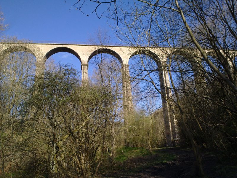
Railway viaduct, now part of Waskerley Walk. 1858 by Thomas Bouch for Stockton
and Darlington Railway. Yellow brick with sandstone ashlar dressings; cast
iron railings. 12 semi-circular arches, 50' diameter and 150' at highest, on
tapered piers with 3-stage buttresses to those at full height, the others
having corresponding detail. Central tallest piers have wide ashlar coping to
3 sides of buttress plinths; each stage has ashlar coping continuous with bands
around piers. Inner pier faces have blind brick arches in each stage, the
lowest with inverted bottom arches. Nosed coping supports railing of intersecting
arcades with linking rings and low block finials; outer stays; short section
renewed at south end. Fifth pier from south has red brick X pattern in north
face; corresponding rough X incised on top coping; function unknown. Rectangular
piers at parapet ends have band continuous with coping.
Source: W.W. Tomlinson, North Eastern Railway, 2nd ed. K. Hoole, Newton Abbot
1967, p 568.
Listing NGR: NZ0959049013
External links are from the relevant listing authority and, where applicable, Wikidata. Wikidata IDs may be related buildings as well as this specific building. If you want to add or update a link, you will need to do so by editing the Wikidata entry.


Other nearby listed buildings
