Approximate Location Map
Large Map »
Latitude: 53.1777 / 53°10'39"N
Longitude: -1.6723 / 1°40'20"W
OS Eastings: 421997
OS Northings: 364559
OS Grid: SK219645
Mapcode National: GBR 585.XNP
Mapcode Global: WHCDF.8DX8
Plus Code: 9C5W58HH+33
Entry Name: Lathkill House Farmhouse
Listing Date: 12 July 1967
Grade: II
Source: Historic England
Source ID: 1109849
English Heritage Legacy ID: 81094
ID on this website: 101109849
Location: Alport, Derbyshire Dales, Derbyshire, DE45
County: Derbyshire
District: Derbyshire Dales
Civil Parish: Youlgreave
Traditional County: Derbyshire
Lieutenancy Area (Ceremonial County): Derbyshire
Church of England Parish: Youlgreave All Saints
Church of England Diocese: Derby
Tagged with: Farmhouse
SK 26 SW PARISH OF YOULGREAVE ALPORT LANE , ALPORT
4/94 (North Side)
12.7.67 Lathkill House Farmhouse
GV II
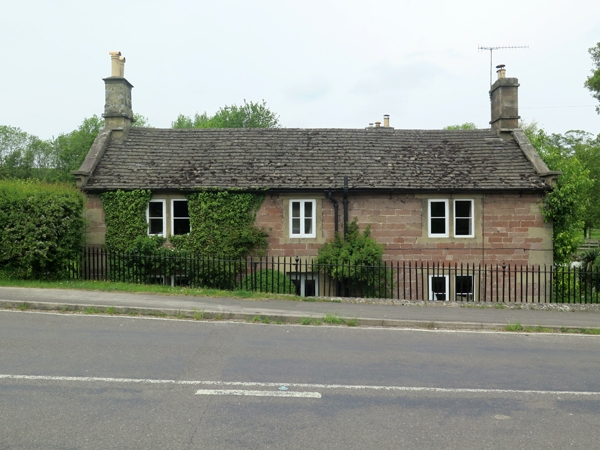
Farmhouse. Late C18 and early C19. Coursed squared sandstone with gritstone dressings
and quoins. C20 concrete tile roofs with stone coped gables and moulded kneelers to
south range. Stone gable end stacks to south, central stone ridge stack to rear
section. Two storeys, three bays, L-plan with early C19, three bay section to rear.
Flush quoined doorcase with raised keystone and C20 glazed panelled door. To either
side 2-light flush mullion windows with two pane casements. Above, two similar
windows and central single light window with flush surround. Whole of ground floor
below road level. East facade to rear has central four-centred arched doorcase with
ovolo moulded edge and C20 plank door. To north, 2-light cavetto moulded mullion
window with pointed lights, incised spandrels and two pane casements. To south of
door similar 3-light window. Above, three similar 2-light mullion windows.
Listing NGR: SK2199764559
External links are from the relevant listing authority and, where applicable, Wikidata. Wikidata IDs may be related buildings as well as this specific building. If you want to add or update a link, you will need to do so by editing the Wikidata entry.


Other nearby listed buildings
