Approximate Location Map
Large Map »
Latitude: 52.6287 / 52°37'43"N
Longitude: -2.4887 / 2°29'19"W
OS Eastings: 367021
OS Northings: 303552
OS Grid: SJ670035
Mapcode National: GBR BW.7G1K
Mapcode Global: WH9DG.R632
Plus Code: 9C4VJGH6+FG
Entry Name: 15, the Wharfage
Listing Date: 9 August 1974
Grade: II
Source: Historic England
Source ID: 1038673
English Heritage Legacy ID: 362233
ID on this website: 101038673
Location: Ironbridge, Telford and Wrekin, Shropshire, TF8
County: Telford and Wrekin
Civil Parish: The Gorge
Built-Up Area: Telford
Traditional County: Shropshire
Lieutenancy Area (Ceremonial County): Shropshire
Church of England Parish: Ironbridge
Church of England Diocese: Hereford
Tagged with: Building
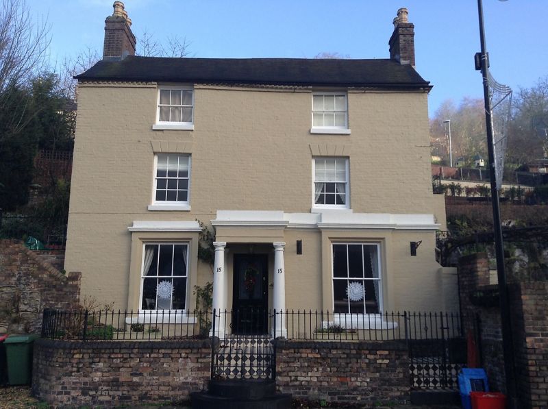
IRONBRIDGE THE WHARFAGE
1.
5362 (north side)
No 15
SJ 6703 NW 15/379 9.8.74
II GV
2.
Late C18. Brown brick; 3 storeys; 2 sash windows with channelled lintels; projecting
bay (one window) with doorway having Tuscan column porch, part-glazed door and modern
brick steps up; brick dentilled eaves; roof with old and new tiles.
Listing NGR: SJ6702103552
External links are from the relevant listing authority and, where applicable, Wikidata. Wikidata IDs may be related buildings as well as this specific building. If you want to add or update a link, you will need to do so by editing the Wikidata entry.


Other nearby listed buildings
